Poor weekend, improving next week, with a great long term outlook

South-east Queensland and Northern NSW Surf Forecast by Ben Matson (issued Friday 25th January)
Best Days: No great days for a little while, due to average/poor local winds. However we'll see a slow improvement (wind wise) next week. Keep an eye out for a small long period S/SE swell late Sun (Mid North Coast) and early Mon (remaining Northern NSW Coast). Otherwise, there's plenty of E'ly swell on the cards from early next week through the weekend and into the adjoining week.
Recap: Minor E/NE swells maintained small peaky waves across most open beaches on Thursday, and winds remained generally light so conditions were clean. A small S’ly groundswell built across the coast on Friday, offering 2-3ft sets at south facing beaches south of Byron, though very little energy made its way north of the border. Freshening N/NE winds confined the best waves to sheltered southern corners.
This weekend (Jan 26 - 27)
Today’s Forecaster Notes are brought to you by Rip Curl
The weekend looks pretty poor for surfers of all persuasions.
Northerly winds will freshen about SE Qld and Far Northern NSW, but strengthen across the Mid North Coast with speeds likely to hold above 20kts.
As it is, there won’t be much surf anyway. Today’s S’ly groundswell will ease throughout Saturday, so apart from early morning when there may be some small sets lingering at south swell magnets (south of Byron) we’ll see a small peaky combo of mainly weak swells, and they’ll be wind affected too.
SE Qld may see a minor increase in trade swell over the weekend as a ridge develops through the Coral Sea, but I can’t see much in it.
We may also see some small, faint E'ly swell from a distant sub-tropical low NE of New Zealand earlier in the week, but I am doubtful for much energy from this source as the fetch was too short and too far away from the mainland.
The only swell of interest for the weekend is expected to reach the Mid North Coast around lunchtime, and build into the afternoon (though it may not reach the Far North Coast until very late). This S/SE groundswell was generated by a small but intense polar low well to the south of New Zealand earlier this week.
Set waves will be very inconsistent - I can’t stress this enough, as it’s a very flukey, distant swell window, so there'll be lengthy periods of tiny conditions - but at its peak (likely overnight Sunday and into early Monday) may provide reliable south swell magnets south of Byron with occasional waves in the 2-3ft+ range. On Sunday, this is mainly expected to occur across the Mid North Coast up to about Coffs or Yamba, so it’ll be worth keeping a close eye on the Coffs Harbour surfcam after 4pm for signs of life.
However, with the expected gusty N’ly winds, there’s really not a lot to get too excited about.
Next week (Jan 28 onwards)
Sunday’s S’ly swell will ease slowly through Monday but should provide extremely inconsistent 2-3ft+ sets early at south facing beaches (south of Byron), before it abates into the afternoon and into Tuesday. This swell won’t favour SE Qld but a handful of exposed northern ends may see stray 2ft+ sets every twenty minutes.
As it is, N’ly winds will ease only slightly into the new week, so expect below-average surface conditions, with the only rideable options inside sheltered northern corners.
The rest of the week will see light to moderate E’ly winds across SE Qld and Far Northern NSW, tending moderate to fresh NE across the Mid North Coast: lighter than the weekend but still enough to cause problems south of Ballina. North of Ballina, conditions won’t be perfect but they’ll be workable, and we may even be so lucky to score the occasional window of variable conditions.
As for surf, we’ve got stacks of sources on the charts.
The weekend’s small ridge through the Coral Sea will broaden in coverage and spread eastward into the South Pacific early in the week, merging up with an interesting trough developing NE of New Zealand (which I’ll get to in a moment).
The associated trade flow will generate plenty of mid-range E’ly thru’ E/NE swell for the whole week, generally building into the 2-3ft range through Monday afternoon and Tuesday, though potentially reaching 3-4ft Wednesday and Thursday. Expect the upper end of this size range in SE Qld, and the lower end across the Mid North Coast.
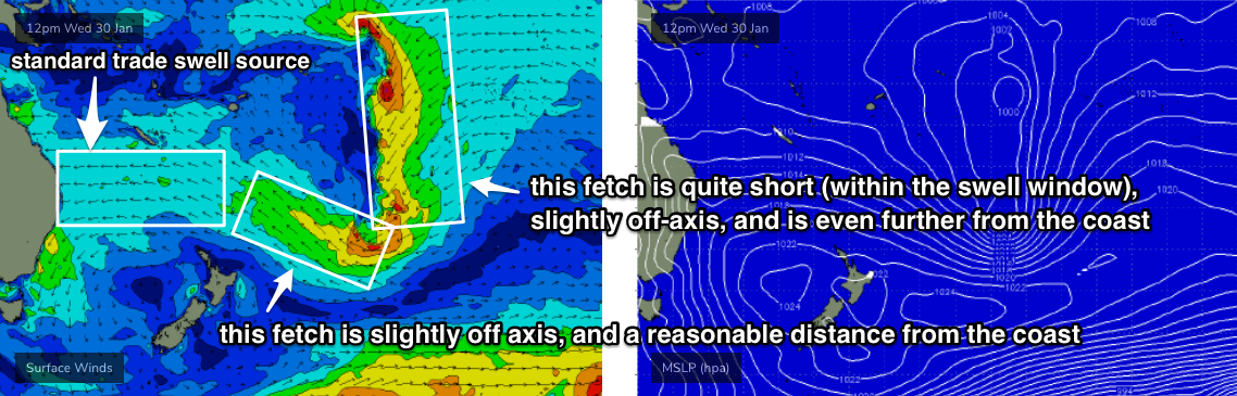
The trough NE of New Zealand is a complex system. It looks amazing on the synoptics, however there are at least two primary fetches (plus a couple of other regions of interest), and they’re both slightly off-axis for our swell window. Adding to this is the large travel distance from the swell source to the mainland.
However, the southern part of the trough will evolve into a sub-tropical low mid-next week and this looks like generating some strong, useful E/SE groundswell for the end of next week, the weekend and into the start of the following week: current indications are that we’ll be under a blocking synoptic pattern, which means it’ll be slow moving, and should provide swell for many days. Let’s book mark wave heights in and around the 3-4ft mark at exposed beaches (again, very inconsistent), and take a closer look on Monday.
Elsewhere, and an intense Southern Ocean low will pass just south of Tasmania on Monday, but it looks poorly aligned within our swell window. We may see some small long period energy glance the Northern NSW coast Tues/Wed but I’m not that confident on anything worthwhile at this stage.
However, a deepening cut-off low south of Tasmania later next week (likely responsible for Friday’s S’ly wind change) looks like it may develop in a much more favourable environment for East Coast swell generation. At this stage it’s worth putting a pencil mark around next Sunday and Monday for a possible significant southerly swell event somewhere on the East Coast.
Lastly, we’re finally looking at some monsoonal activity across the top end next week, which should bring about an increase in troughiness and thus tropical weather systems with swell generating potential for the Coral Sea. Certainly nothing to pin down at this point in time, but the potential is increasing after what’s been a dormant couple of weeks in this neck of the woods.
Anyway, that’s more than enough to digest - have a great long weekend, I’ll see you Monday.
Comments
There hasn’t been good waves since grade 9
Huey owes us a June/July cyclone or two now.
When's the next surf god elections? Huey refuses to answer my emails, has delivered nothing but empty promises and 2nd rate swell events smothered by onshore winds.
I've seen the ads.... Clive Palmer's gonna make surfing great again. He's got my vote.
Winds
Northerly 15 to 20 knots, reaching up to 30 knots south of Cape Byron during the afternoon and evening.
Monday 28 January
Winds
Northerly 15 to 20 knots, reaching up to 25 knots south of Cape Byron early in the morning. Winds turning northeasterly in the late morning.
Tuesday 29 January
Winds
Northeasterly 15 to 20 knots.
Alright, alright; we get the fucking picture.
Relief is finally on the way by the looks of it.
look on the bright side,takes all the guess work out of it.
Haha!
it's a war of attrition now.
Any swell north of Bundaberg this coming week?
Actually looking forward to that new S swell mixing up against the N windswell at a protected spot this arvo. Tides look good too. Think positive. C'mon Huey. Give us something!
No sign of S swell at the exposed S facing rock ledge I fished this arvo .....anything down there Crg.
Monday 28 January
Winds
Northerly 15 to 20 knots, reaching up to 25 knots south of Cape Byron early in the morning. Winds turning northeasterly in the late morning.
Seas
2 to 3 metres, decreasing to 1 to 1.5 metres during the morning.
Swell
Southerly around 1 metre.
Weather
Mostly sunny.
Tuesday 29 January
Winds
Northeasterly 10 to 15 knots.
Seas
1 to 1.5 metres, decreasing to 1 metre during the morning.
Swell
Southerly around 1 metre.
Weather
Partly cloudy.
Wednesday 30 January
Winds
Northeasterly 10 to 15 knots.
Seas
Around 1 metre, increasing to 1 to 1.5 metres south of Cape Byron.
1st Swell
Southerly around 1 metre.
2nd Swell
Easterly around 1 metre.
Weather
Partly cloudy.
The thing about this pattern is instead of moderating, its fucking intensifying.
2/3 of the way through summer and we're balls deep in a week long nuclear northerly.
At least the flathead game should be strong by now, probably sick of them, thus chasing a jewie
actually I've been smashing big greenback tailor on poppers last 2 days.
insanely fun fishing on light gear.
found a corner where the relentless northerly seems to have concentrated them.
Good fun the big choppers
And now you’ll get to do that whilst wearing a life jacket, Richmond council adopts life jacket policy for rock fishing
Seriously, what’s next, surfers and swimmers have to wear a PDF?
Nanny country, time to remind them who pays their wages
What the.....? next Saturday southeasterly winds, can anyone enlighten me what they are?....... This has gone beyond the ridiculousness!!
Be interesting to see if there’s anymore sand on the points this next swell
the Points down here have actually had the sand gouged out and holes punched in them by the constant assault of short period NE windswell.
not good.
we need longshore drift from the opposite direction to move the sand slabs back into position.
Yesterday arvo's imagined session of new S swell meeting N windswell and colliding into random 3ft peaks up and down the beach with no one out was just that...my imagination. A comprehensive slap in the face for all those "think positive" and "believe in it and it will happen" types. They can fuck right off with my unequivocal evidence to the contrary.
Bummer mate. Craig was on the MNC yesty and scored really nice 3-4ft waves as the new south swell pushed through in the arvo.
It looked like it was in the water yesterday arv but the direction looked a little off and it just wasn't bending into my local. Strangely I took the family to the same beach this morn and it was bigger and I managed to sneak a couple of quick ones.
That all it takes sometimes, eh? A second or two less (or more!) in swell period or a couple of degrees swing in swell direction can turn the tap off at one spot and on at another.
I haven't checked the points near you, FR, but the SE facing stretches and particularly southern corners of those stretches are chokkas with sand ATM.
Can you imagine how rabid the crowd will be next time any of the well known point turn on? I will be no where near them.
A local swell magnet that was handling the northerly this morning was completely reamed! Couldn’t bring myself to join the holiday hoards
No sign of S swell here yesterday up to dark, and none this morning at S facing backbeaches.
water dropped a few degrees overnight.
1-2ft closeouts.