Continual trade swell ahead, with generally good conditions

South-east Queensland and Northern NSW Surf Forecast by Ben Matson (issued Wednesday 2nd January)
Best Days: Entire period: strong trade swells, biggest over the weekend. Generally OK winds in most regions, except the MId North Coast, which will remain problematic until Sun PM, when we'll see winds tend light and varibale, holding through Mon and Tues AM.
Recap: Jeez, it’s been an unreal run of quality trade swell across some coasts over the last few days, with sets around the 3-4ft mark and periods of light winds at times; even the onshores haven't been too much of an issue when they've been up. Wave heights have been a little smaller across the Mid North Coast and the NE breeze has been stronger here, as expected.

Stacks of trade swell at Currumbin today
This week (Jan 1 - 4)
Today’s Forecaster Notes are brought to you by Rip Curl
Monday’s notes referenced a near-stationary synoptic pattern, and it’s set to continue for the next little while.
A large Tasman high pressure system will remain the dominant factor towards our surf conditions up until a brief southerly change pushes up across the Southern NSW coast on Sunday, offering the first respite in problematic northerlies for the Mid North Coast.
Elsewhere (i.e Far Northern NSW and SE Qld) we’ll a continuation of light and variable tending light to moderate onshore winds, and thus generally favourable conditions for most regions.
As for surf, the existing trade swell will hang around for quite some time, reinforced later Thursday and into Friday from a slightly longer period E/NE swell, generated by a sub tropical low that developing at the tail end of the broad trade flow on Monday. I’m not expecting much more size than the pre-existing trade swell (inconsistent 3-4ft sets across exposed coasts, smaller running down the points) but it will however provide a more uniform size distribution - i.e. down to the Mid North Coast, which has seen slightly smaller surf from the current trade swell.
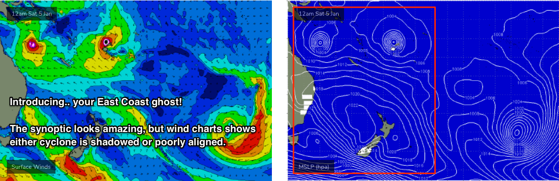
In Monday’s notes I mentioned a chance for a small, rare N’ly swell to push down the coast later Friday, originating from the redeveloping Tropical Cyclone in the Coral Sea, TC Penny.
This is now less likely to occur, not because of where TC Penny is positioned or its strength, but because of where the models are forecasting its strongest winds to be. In any case, it doesn’t matter much because the easterly swells were always meant to be the dominant sources.
In fact, as TC Penny starts to re-intensify we’ll see the supporting ridge to the south strengthen, and this will generate bigger E/NE swells for the weekend that’ll start to muscle up in size late on Friday afternoon. At this stage the Sunshine Coast should push 4-5ft at exposed spots by late Friday, with smaller surf to the south (similar to the pre-existing trade swell) but the main increase in size may not appear properly until Saturday, peaking Sunday.
Lastly, we’ll see a small long period S’ly groundswell across Northern NSW on Friday, generated by a deep Southern Ocean low passing south of Tasmania over the last few days. This system is very strong and broad, but poorly aligned within our swell window. As such, the models are expecting large periods (~17 seconds) but with small swell sizes (0.3m). This is likely an undercall, but in any case only south facing beaches south of Byron will benefit from this energy - we should see occasional 2-3ft sets at those spots.
Given the recent lack of southerly swell accompanying the persistent N/NE breezes across the Mid North Coast, we should see some welcome (if relatively small and very inconsistent) waves at south swell magnets.
This weekend (Jan 5 - 6)
So, local winds will remain much the same over the weekend as what we’re expecting on Thursday and Friday. That is, light and variable tending light to moderate onshore across SE Qld and Far Northern NSW.
The Mid North Coast will continue to see fresh N/NE winds on Saturday but an advancing trough from the south will bring about a period of light variable winds on Sunday. It’ll move progressively north during the day (i.e. impacting Seal Rocks first, then Port Mac, then Coffs etc) so the northern Mid North Coast locales may not see an improvement until the afternoon. I’ll firm up the specifics on Friday.
As for surf, Friday’s E’ly swell will hang around though ease slightly over the weekend, and the S’ly swell will be all but gone, however we’ll see building E/NE swells from the broad ridge south of Tropical Cyclone Penny.
Additionally, we should also see some smaller, but slightly longer period NE swell from TC Penny itself. The main fetch around TC Penny will be aimed towards Central and Northern Qld coasts, but its slow moving nature and broad width should favour a good spread of energy southwards.
As such, I’m expecting wave heights to build into the 5-6ft range across the Sunshine Coast over the weekend, with marginally smaller surf across the Gold and Tweed Coasts (between 4ft and maybe 6ft), and then slightly smaller as you progress down to the Mid North Coast (3-4ft).
Sure, conditions won’t be epic thanks to (at times) moderate E’ly winds, but with a consistent mix of easterly swells there’ll be waves just about everywhere and we'll see occaisonal periods of variable winds.
It's also worth mentioning that another Tropical Cyclone will develop near Fiji later this week but it’ll remain shadowed by Fiji and New Caledonia, and it’ll also be unfavourably aligned in our swell window. As such it’s not seen as a significant swell source for us right now (though, it will help to maintain the trade flow to the south, stretching into the South Pacific - so it’s technically an indirect source of energy).
Next week (Jan 7 onwards)
At this stage we’re looking at a continuation of steady trade swells through most of next week, thanks to TC Penny remaining slow moving in the Northern Coral Sea. It’ll be positioned outside of our primary swell windows, but will keep the trades active throughout broader easterly swell windows and this should keep size anywhere from 4-5ft across SE Qld, down to 3ft+ across the Mid North Coast from Monday thru’ almost Thursday of next week.
Winds should remain similar too; light and variable tending moderate easterly across most regions. Sunday’s late incursion of variable conditions across the Mid North Coast should persist into Monday and early Tuesday but it looks like the northerlies will become established from late Tuesday or Wednesday onwards.
Elsewhere, and we have a couple of poorly positioned sub tropical lows well to the east of New Zealand that will generate small long period E’ly swell for our region, but considering the more prominent local swell sources its not worth getting too excited about.
See you Friday!
Comments
Finally an offshore this morning, got a couple of crackers on the sunny coast this morning even with a full tide!
Lines for days at Byron. What an unreal Xmas/New year it's been!

Unreal Xmas/New Years?????????
You must have a very short memory.
I've been surfing Pass/backbeaches every day.
I'd give it a C minus. Generally reliable little tradewind swell but pretty constant onshore flow.
Certainly nothing to write home about.
Yeah agree,c minus but better than nothing..but the big thing around here is the banks are finally coming back with these conditions which is great ...been a couple years of poor to no banks so keep it coming Huey.
beachies here are still mostly pretty straight.
Pass and other back beaches have been fun but just insano crowds.
All in all, with what the synoptics have looked like at various times over the past 2 weeks the resultant surf is pretty disappointing.
Still enough to ride everyday and have fun.
Couldn't agree more Steve!!! Banks are shit here. Although there is a select few if you know where.
Last week or more of beaches have been unreal around here.
Been no shortage of swell potential that's for sure. What a shame the sand distribution is still cactus on the points or we'd be in a classic period right now. Still it's been nice getting fun waves everyday
Thanks Huey.
Got 4ft cranking barrels on a sunny coast beachie this morn.
When on gods earth are we going to see any wind with the letter "S" in it!!!
The current forecast retrograde (EC has much more favourable location for us) of that low pressure system south of Fiji over the weekend and into early next week looks very tasty indeed!!
Had a very fun surf at Sunshine beach this arvo. Light onshore but peaky 3-4ft punchy waves in bath warm water in boardies.
Couple sneaky tubes too.
This morning was pus
Sunshine has been okay. Except for bluebottle and snapped leggie. More power and better shape today.
Coming from Victoria where I only surf in boardies a few times a year today was great