Fun mix of east and south swells this week, ahead of weekend E/SE swell
South-east Queensland and Northern NSW Surf Forecast by Craig Brokensha (issued Monday 5th February)
Best Days: Both coasts Sunday and Monday mornings, Tuesday morning Surf Coast, Wednesday morning Surf Coast, Thursday both coasts
Recap
A large reinforcing pulse of S/SE groundswell across the North Coast Saturday morning came in at 4-6ft on the sets, while background E'ly swell continued in the 2-3ft range. Morning offshores gave into gusty S/SE-SE winds through the day.
The Gold and Sunshine Coasts hung around 3ft on the sets, cleanest each morning, while south magnets picked up larger waves.
This morning the swell was smaller again across SE Qld, but we've since seen an inconsistent E'ly groundswell fill in, offering infrequent 3ft sets.
The North Coast hung in around 3ft out of the S/SE and E with a few bigger one still in the mix at south magnets.
Today’s Forecaster Notes are brought to you by Rip Curl
This week and weekend (Feb 6 – 11)
These notes will be brief-ish as Ben’s away today.
Our fun week of waves is still on the cards, with a distant and very inconsistent E'ly groundswell that is evident in the water this afternoon expected to build further this evening and peak at Ben's estimates of 3-4ft+ tomorrow morning.
This swell was generated last week, north-east of New Zealand by a tropical low in an established trade-flow.
 Due to the large distance between the swell source and us, we'll see long waits between sets.
We should see the swell easing through the day, down further Wednesday from 2-3ft.
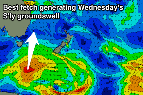
Also in the mix across the North Coast will be a building S'ly groundswell later tomorrow, ahead of a secondary stronger pulse Wednesday, peaking through the mid-late morning/early afternoon.
These swells have been generated by a good broad and slow moving polar frontal progression that's produced a fetch of strong to gale-force SW winds from south of Tasmania, up towards New Zealand.
The first pulse may be seen later Tuesday across the Mid North Coast but Wednesday morning should reveal 3-4ft sets at south magnets, with the secondary pulse through the day providing larger 5ft sets.
SE Qld isn't due too see much above 2-3ft at south magnets Wednesday, with the easing E'ly swell the more dominant.
Winds look favourable early each morning and from the SW, tending SE through the morning and freshening each day all this week. The Mid North Coast should see slightly better W/SW winds some mornings.
Into Thursday the S'ly swell will be easing from 3-4ft across south magnets on the North Coast, while SE Qld will see a mix of E, SE and S swells around 2ft+.
Moving into the weekend and we're due to see some inconsistent background S/SE groundswell across the North Coast from a polar fetch of distant S/SE winds, but of greater importance is a new E/SE swell through Saturday and Sunday.
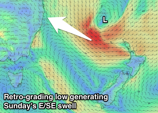
 The source of this swell will be a broad tropical low drifting slowly south towards New Zealand as a strong supporting high moves in over New Zealand.
Initially a strengthening fetch of E/SE trades will be cut in half by the North Island, but we're expected to see the low retro-grade west towards us later this week before the system falls apart in the Tasman Sea on Saturday.
A fun E/SE swell is expected from this low on Sunday, with Saturday see some building E/SE swell from the ridge in the Tasman Sea, reaching 3-4ft across open beaches in both regions by dark with a peak Sunday to 4-5ft across the North Coast (if not for the odd bigger bomb) and similar in SE Qld. With the swell direction the points are likely to more around 4ft.
Winds are the main issue, with morning W/SW offshores Saturday and E/NE sea breezes, while Sunday will see a W/NW-NW offshore, ahead of gusty N/NE winds and a possible late S'ly change. This isn't ideal at all for the points, though the Mid North Coast should see the change through the morning.
Longer term the outlook remains very active with strong topical activity north-east of New Zealand expected to generate plenty more E'ly swell mid-late next week. More on this Wednesday.


Comments
That east swell was a non-event? Couple weak 3ft sets every half hour. Pretty windy anyway.
Sunny Coast saw mostly SSW winds in the morning. With the tide coming in from low, swell was a reasonably consistent 3ft with occasional 4-5ft. Good call by Ben
where was it 4-5 ft on the SC
where was it 4-5 ft on the SC
Haven't been online much in the last few days, but from what I saw it looks like the long range east swell came under expectations across the SE Qld/Nthn NSW region and was super inconsistent too (though Southern NSW picked up the expected size).
barely showed here.
Is that your missus who does the Mamabake book? Congrats on the distribution deal if it is!
Maybe every 5-10minutes there were 4ft sets and bomb 5ft from maroochydore to alex sc from low until about 8am when I left. But it was early, so maybe I was dreaming.
Maybe every 5-10minutes there were 4ft sets and bomb 5ft from maroochydore to alex sc from low until about 8am when I left. But it was early, so maybe I was dreaming.
I call BS on the 5ft claim