Fun mid week swells, best suited to Northern NSW
South-east Queensland and Northern NSW Surf Forecast by Ben Matson (issued Monday 25th December)
Best Days: Wed/Thurs: peaky east swell, with generally OK winds. Sun: low confidence for a small, very inconsistent E/SE swell across the Gold/Sunny Coasts with a period of OK winds in the arvo.
Recap: There hasn’t been much surf over the last few days. A minor trade swell pulsed across SE Qld over the weekend and Friday’s south swell persisted across Northern NSW into Saturday before easing Sunday.
Today’s Forecaster Notes are brought to you by Rip Curl
This week (Dec 27 - 29)
We’ve got a small increase in swell due for Northern NSW over the next few days.
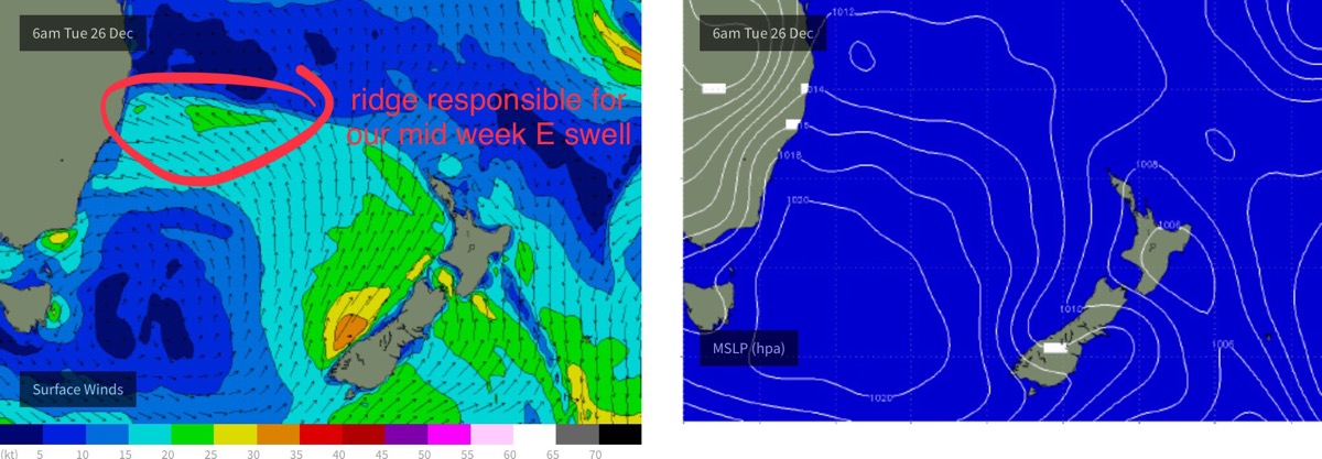
A ridge is building through the central Tasman Sea, and it’ll generate a mid range east swell (tending E/SE and then SE as you head north) that’ll be biggest across the Mid North Coast, reaching a peak of 3-4ft on Wednesday. Surf size will become smaller as you head north from Yamba, with a peak around 2-3ft+ expected at exposed beaches in and around the Ballina region.
SE Qld will see less size due the larger distance from the source and also the less favourable coastal alignment. Most beaches and points will see slow 1-2ft waves but exposed northern ends should pick up occasional sets between 2ft and maybe 2-3ft if we’re lucky. If anything, the upper end of this size range is more likely across the Gold Coast than the Sunshine Coast.
Expect smaller size either side of Wednesday’s peak; it’ll ease steadily through Thursday and will bottom out on Friday with tiny leftovers.

Conditions should be OK for the next few days with mainly light onshore tending variable winds, but freshening northerlies are expected on Friday. Fortunately, this will occur as the swell bottoms out so there’ll be no great loss. We'll see more wind strength in the south than in the north but in any case you should aim to surf either Wednesday or Thursday for the best waves.
Elsewhere, a tropical low south of Fiji at the moment looks good on the synoptics but it’s not very large nor very strong, and is tracking away from us. As such its swell potential is minimal for our region.
This weekend (Dec 30 - 31)
With freshening northerly winds ahead of a shallow southerly change this weekend, the surf outlook isn’t great. A small level of N’ly windswell may build across the Gold and Tweed Coasts but I don’t think there’ll be much in it.
The only swell source of any note is an extremely distant E/SE groundswell generated by a deep mid-latitude low well east of New Zealand (and south of Tahiti) over the weekend. This swell should build slowly through Saturday ahead of a peak on Sunday but we may see up to 20 minutes or more between sets. There’s a chance a few exposed beaches north of Byron may pick up stray 2ft+ sets (greatest chance for this on the Sunny Coast), but with the tricky wind outlook and low confidence on the swell size, I wouldn’t book anything in.
Sunday afternoon is probably your best time to capitalise on this potential event, as we should see the weekend northerly flow abate as the southerly change approaches from the south. However due to the shadowing of New Zealand, it’s unlikely we’ll see much size south from Byron.
Next week (Jan 1st onwards)
There’s nothing of any major interest in the long term forecast at this stage.
A deep low will track south of Tasmania over the weekend but it’ll be poorly aligned within our swell window. We should see some minor long period southerly energy glancing the coast around Tuesday or Wednesday but it’s unlikely to generate any major size for our region.
The weekend's southerly change will be linked in with a surface trough that is expected to meander about the Tasman Sea through the first half of next week though there's currently no swell generating potential from it. I will keep a close eye on the model guidance over the coming days though.
Elsewhere the synoptics look a little benign. Let’s see how it might appear in Wednesday’s update.

