Small surf ahead, mid-next week looks OK
South-east Queensland and Northern NSW Surf Forecast by Ben Matson (issued Wednesday 20th December)
Best Days: No great days. Maybe Thurs AM for some small peaky NE waves on the Mid North Coast. Otherwise mid-next week onwards looks OK.
Recap: Small swells and mainly northerly winds. Nothing overly worthwhile. Building NE windswell on the Mid North Coast.
Today’s Forecaster Notes are brought to you by Rip Curl
This week (Dec 21st - 22nd)
A trough moving up the coast will disrupt the N’ly flow off the Mid North Coast on Thursday. The small windswell seen today will ease steadily though early morning could see some exposed NE facing beaches picking up occasional 2ft, maybe 2-3ft waves before it eases to 1-2ft during the day. Conditions won’t be amazing but with variable winds in general it’ll be much better than today.
The trough will however stall off the coast, maintaining light to moderate N’ly winds north from about Yamba or Ballina on Thursday. They’ll start to ease into the evening but with only small swells on offer on Thursday it’s not really worth working around the protected northern corners, as the surf will be pretty lacklustre.
Light variable winds are then expected Friday with a small mix of residual swells across all coasts, including some small short range S/SE energy from a fetch at the southern end of Thursday’s trough. This will however only favour the Mid North Coast. Everywhere else will see a small linger trade swell out of the E/SE.
The only other interesting feature for Friday is a possible long period S’ly groundswell glancing the coast (south swell magnets south of Byron), from a deep Southern Ocean low currently south of Tasmania (which has generated a morning spike in sig wave heights at Cape Sorell, off Tasmania’s West Coast, to 5.5m).
This system is poorly aligned for our region and tracking in an unfavourable direction, but we still can’t ignore the sheer strength and width of the fetch. As such I am still estimating a handful of reliable south facing beaches on the Mid North Coast and Northern Rivers may pick up some occasional 2ft+ sets throughout the afternoon, as the swell energy glances the coast enroute to Fiji. It is unlikely to favour SE Qld though.
This weekend (Dec 23rd - 24th)
A minor southerly extension of the trades on Thursday and perhaps Friday will set up a small pulse of trade swell for SE Qld over the weekend. I’m doubtful we’ll see much more than 1-2ft at exposed beaches, but it should otherwise stop the coast from becoming flat.
Winds will remain light and variable tending northerly north of Ballina, but an approaching trough from the south will freshen the N’ly flow into Saturday afternoon and Sunday across the Mid North Coast.
As for other swell sources, a second, slightly stronger long period S’ly groundswell from the Southern Ocean low is due to arrive throughout Saturday (easing into Sunday) across Northern NSW. However, thanks to the poor alignment and track of the low, confidence is not high at all as to whether we’ll see much if any surf. If we saw inconsistent 2-3ft sets at south swell magnets south of Byron, I'd be very stoked.
These flukey south swells sometimes benefit just a handful of locations so I’d be wary about putting in any major mileage chasing surf. The models certainly don’t like this swell though it wouldn’t be the first time they’ve missed such an acute pulse of directional energy.
Next week (Dec 25th onwards)
Christmas Day looks pretty drab in the surf department, with low residual swells and northerly winds.
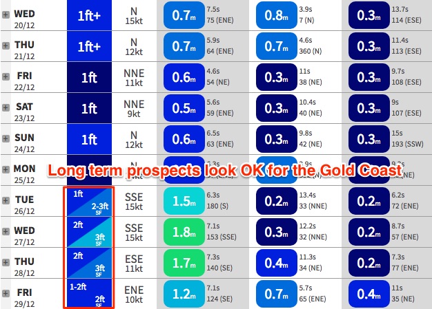
A gusty S’ly change is expected into the Mid North Coast around luchtime Monday, extending north to the border in the early hours of Tuesday morning. This change will deliver a small windswell of low quality to most regions (into Tuesday), however a building ridge through the northern Tasman/lower Coral Sea from Tuesday onwards should kick up a more appreciable level of trade swell from Wednesday onwards. This should be enough to get the outer points running with small surf.
In fact, there is a suggestion we could see a deepening trough well off the Qld coast over the following days, which would tighten the E’ly squeeze and bring about a more prominent increase in short range E’ly swell through the back half of the week. But it’s still very early days yet.
Otherwise, the other long term possibility hinges around a potential low off New Zealand’s South Island early in the week, which may set up a SE swell mid-late week. Let’s take a closer look at this on Friday.


