Small east swell for the next few days, with dicey winds
South East Queensland and Northern New South Wales Surf Forecast by Ben Matson (issued Wednesday 22nd July)
Best Days: Small peaky east swell most days, with tricky winds Thurs/Fri. Best Sat and Sun tho' size will be gradually easing. Tues onwards: large S'ly swell for exposed beaches in Northern NSW, great for the semi-exposed points. Small surf in SE Qld from this source.
Recap: The solid south swell we saw over the weekend and into Monday eased slowly through Tuesday and this morning. A small E’ly trade swell also pushed up across the region yesterday and was the dominant swell train in the water north of Yamba today. Winds have been variable across the region, with mixed conditions at times, but there have been pockets of good surf, especially across the Mid North Coast where a more established offshore flow has been prevalent. As a side note, a small long period S’ly swell was also detected across many NSW buoys on Tuesday, reaching Eden early morning, Port Kembla late afternoon, and then Crowdy Head early this morning. However as expected it hasn’t translated to much size in the surf zone.
This week (July 23 - 24)
Our recent south swell is disappearing across the region, and the east swell we’ve seen over the last couple of days will continue to motor along as-is. Our model has a small kick in size for tomorrow (in SE Qld), but I can’t quite see where it’s originating from - part of the problem is that the easterly flow along the top of the Tasman high is a little disjointed, which means the swell source is a little erratic and we can see lully periods at times.
But the main problem we have for the next few days is the threat of north-east (then northerly) winds. This is more of a concern in the southern regions - for example the Mid North Coast - than locations north of the border, however it’s likely that even a variable morning breeze in SE Qld will swing north-east during the day. So, make the most of the early session for the best waves.
As for size, most beaches in SE Qld and Far Northern NSW are looking at peaky 2-3ft surf both days, maybe a few bigger sets on the Sunny Coast at times. Smaller surf is expected south of Ballina.
So overall, keep your expectations low and you’ll pick up a few peaky beach breaks. But on the balance the next few days are certainly not worth rearranging your diary for.
This weekend (July 25 - 26)
The weekend looks OK for the open beaches. It’s a little frustrating woking with an unreliable swell source such as this patchy trade flow, but it’s all we’ve got (and let’s be honest, this time of year any east swell is a bonus).
Right now the most likely scenario is for wave heights to maintain strength (!) through Saturday before easing Sunday. I can’t find any reason to change the expected surf size from earlier indications, that is 2-3ft waves at open beaches across most of SE Qld and Far Northern NSW on Saturday, easing to 2ft on Sunday.
We’ll see smaller surf south of about Ballina or Yamba too, and keep in mind that the surf won’t be particularly strong.
As for local winds, a series of vigorous frontal passages across the SE corner of the country will freshen winds from the western quadrant over the weekend. This will be mainly felt across the Mid North Coast but either way it’ll be offshore in most areas, just a little gustier in the southern regions.
So aim for Saturday for the most size, but there’ll be small peaky beaches at swell magnets through Sunday too.
Next week (July 27 - 28)
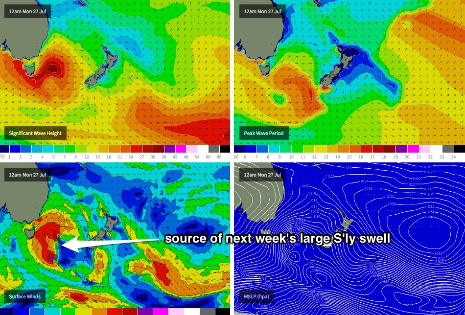
A deep low pressure system is expected to track across Tasmania later Sunday, and will push into the southern Tasman Sea on Monday (see chart below). This should kick up a strong southerly swell for the region from about Tuesday onwards (maybe a late kick across the Mid North Coast on Monday).
Additionally, a secondary low is expected to form east of Tasmania, and track northeast - this should maintain strong southerly swell through into Wednesday however we’re likely to see winds veer more to the south as this system pushes close to the mainland.
As for size, Monday will probably remain very small with residual east swell, and perhaps some small southerly swell in the south to begin with - but by late afternoon the Mid North Coast should be up into the 3-5ft range. Tuesday should see large 6-8ft surf at south facing beaches across Northern NSW, though they will be wind affected so semi-exposed points will be your best option.
We may potentially see a similar size range into Wednesday morning but an easing trend is expected from the afternoon onwards.
And as for SE Qld, surf size will be considerably smaller north of the border - south facing beaches will see all of the size (4-5ft at the height of the swell) but most Gold/Sunshine Coast beaches are looking at 2ft+ surf threough Tuesday and Wednesday, with semi-exposed points seeing bigger waves near 3ft+. Let’s take a closer look at this on Friday.


Comments
Shame about the light northerly wind as there's otherwise a few fun waves across the Goldy.