Windows of light winds for the South Coast from the weekend

South Australian forecast by Craig Brokensha (issued Wednesday January 29th)
Best Days: Mid Coast for a novelty wave today, Saturday morning for the keen down South, Sunday morning down South, Monday down South, Tuesday morning down South
Features of the Forecast (tl;dr)
- Easing mid-period S/SW swell over the coming days with fresh S/SE winds tomorrow, lighter E/SE Fri AM ahead of fresher sea breezes
- Small-moderate sized, inconsistent SW groundswell for Saturday morning with a slightly better mid-period swell for the PM, easing Sun
- Light E/NE tending fresh S/SE winds Sat
- Variable Sun AM, freshening from the S/SW into the PM
- Small S/SW groundswell Mon with variable winds ahead of weak sea breezes
- Easing swell Tue with N/NW winds ahead of a strong S/SW change
- Mix of swells Wed with strong S/SE winds
- Better, inconsistent SW groundswell Thu with E/SE-SE tending S/SE winds
Recap
Yesterday was poor across both regions with cross-shore winds and a tiny swell inside the gulf, onshore down South but improving a little into the afternoon with some new swell and easing winds.
Today we’ve got our new mid-period S/SW swell in the water with full but improving 1.5ft sets inside the gulf, 3ft+ down South and with less than ideal conditions that have improved for a period as winds tipped more E.
This week and weekend (Jan 30 - Feb 2)
The current mid-period S/SW swell should hold well into tomorrow morning across the state thanks to the swell generating source being drawn out in nature yesterday.
Easing surf from 3ft is due across Middleton with 1ft+ waves on the Mid, smaller into Friday.
Local winds will continue to favour the Mid Coast with the South Coast seeing persisting S/SE winds tomorrow, lighter E/SE on Friday morning but with the smaller swell, it won’t be great.
The weekend and early next week look better for a surf down South as pressure gradients relax across the state leading to more favourable local winds.
A light E/NE breeze is due Saturday morning ahead of sea breezes with a new, inconsistent SW groundswell due to be in the water, followed by some slightly more consistent mid-period SW swell for the afternoon, easing Sunday morning.

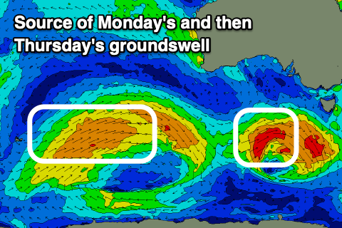
As touched on in Monday’s notes, a strong but distant low will generate Saturday morning’s swell, with slow 2ft+ sets expected across Middleton, tiny on the Mid Coast.
The mid-period energy will be generated by a now, weaker frontal progression that’s currently to our south-west.
This progression has been downgraded a touch and with that the size only looks to reach 2-3ft across Middleton Saturday afternoon, easing from 2ft+ on Sunday with the Mid Coast likely only to be around 1ft+.
Winds on Sunday morning look variable, likely tending light offshore across the South Coast ahead of freshening S/SW winds into the afternoon, variable again Monday morning and remaining light most of the day.
A small pulse of new SW groundswell is due on Monday, but the strengthening low linked to it will track unfavourably south-east under the country on the weekend.
A quick burst of W’ly gales generated late through our southern swell window isn’t expected to generate much size but Middleton should hold 2ft+ through the morning, easing into the afternoon and smaller Tuesday.
Morning offshore winds are due Tuesday but a trough will bring a strong S/SW change early afternoon, with poor S/SE winds into the middle of the week.
This change should be followed by some new mid-period swell Wednesday then some distant groundswell Thursday but we’ll review this Friday.