Attention slowly winds to the Mid Coast
South Australian Forecast by Craig Brokensha (issued Monday December 2nd)
Best Days: Today South Coast, later tomorrow Mid Coast, both coasts Wednesday morning, South Coast Thursday morning, Friday morning Mid Coast, Saturday morning Mid Coast
Features of the Forecast (tl;dr)
- Temp low point in swell tomorrow AM with early W/NW tending fresh SW winds mid-AM, tending late S/SE on the Mid
- Moderate + sized W/SW groundswell building into the PM, peaking Wed, easing a touch Fri
- E tending fresh SW winds Wed on the Mid E/NE-NE tending fresh SE down South
- Fresh NE-N/NE tending variable then SW winds Thu, N/NE down South in the AM
- Reinforcing W/SW swell Fri, easing Sat
- Variable tending fresh S winds Fri, S/SW Sat down South with early S/SE winds on the Mid Coast
- Gusty S/SE winds Sun
Recap
Winds had a bit of west in them both Saturday and Sunday morning’s, favouring the Middleton end of the South Coast with easing 2-3ft sets on Saturday, smaller yesterday. The Mid Coast was only tiny and suited to beginners.
Today, conditions are clean and fun again with a new, inconsistent W/SW groundswell in the water that’s providing slow 2-3ft sets across the Middleton/Goolwa stretch.
The Mid Coast isn’t seeing much of this long-range swell and conditions are bumpy and wind affected in any case.
This week and weekend (Dec 3 - 8)
Today’s long-range W/SW groundswell is due to ease into tomorrow and a trough will bring a W/NW tending SW breeze from mid-morning so early is the go for easing, slow 2ft waves across Middleton.
The Mid Coast will be tiny and wind affected most of the day, but into the afternoon our first pulse if westerly swell is due, ahead of the better size on Wednesday.
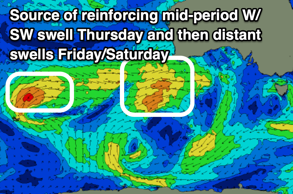
As touched on last week, the source was a strong, slow moving low firing up to the south-west of Western Australia on the weekend.
A fetch of strong to gale-force W/SW winds should produce some inconsistent but good 2ft waves into tomorrow afternoon as winds shift S/SE before dark, while Wednesday should see 2-3ft sets on the favourable parts of the tide, with Thursday dropping back to 2ft or so.

Middleton will see a bit less size owing to the westerly angle with Wednesday looking to come in at 3ft+ before easing back to 2-3ft on Thursday.
Local winds on Wednesday look favourable for both coasts, E’ly across the Mid and E/NE-NE down South ahead of fresh sea breezes with Thursday seeing a little bit of north in the wind, coming from the N/NE across the Mid Coast but great for the South Coast ahead of a late SW change.
The trough linked to the change looks relatively weak with winds due to go back variable offshore on Friday morning.
Swell wise, persistent frontal activity behind the low, passing under Western Australia mid-late week should maintain 2ft sets across the Mid Coast Friday, easing from 1-2ft on Saturday and then tiny Sunday.
The South Coast isn’t due to see much energy at all thanks to the acute westerly nature and looks to hover around a slow 2ft max on the sets.
Winds on the weekend look a touch dicey thanks to a trough moving through Friday afternoon leaving S/SW winds down South on Saturday and early S/SE winds across the Mid Coast.
These winds will strengthen through the day and then persist out of the S/SE on Sunday but we’ll look at this in more detail Wednesday.
Longer term the pattern looks to consist of winds from the south-eastern quadrant with smaller swells so make the most of the coming week.

