The Mid Coast continues to shine
South Australian Forecast by Craig Brokensha (issued Friday October 11th)
Best Days: Mid Coast today, Mid Coast tomorrow, South Coast early Sunday, Mid Coast into the PM, South Coast Tuesday, Mid Coast Wednesday afternono and Thursday
Features of the Forecast (tl;dr)
- Moderate + sized mix of easing W/SW swell tomorrow and new SW energy with E tending weak W/SW winds on the Mid, fresh E/NE tending E/SE-SE down South
- Easing swells Sun with early N/NE tending N/NW then SW winds late AM, easing a little after the change
- Smaller background W/SW swell Mon with moderate E/SE-E winds
- Moderate sized S/SW groundswell for Tue with fresh NE winds
- Moderate sized, inconsistent W/SW groundswell building Wed PM, holding Thu with strong S-S/SE winds Wed, E/SE Thu
Recap
Yesterday started poor across both regions with a strong but easing onshore wind across the South Coast, tiny and windswelly across the Mid Coast. Later in the day some better W/SW swell started to show across the Mid Coast but today is the pick with a peak in energy and clean 2-3ft sets.
The South Coast remained bumpy and to 3ft with more swell on the way.

Solid and clean this morning
This weekend and next week (Oct 12 - 18)
Today’s W/SW groundswell was generated by a strong frontal progression that moved through the southern Indian Ocean earlier this week. This is favouring the Mid Coast, but a secondary better aligned (for the South Coast) SW groundswell is due into tomorrow, generated by the same progression as it moved under Western Australia mid-week, with a trailing fetch of W/SW winds continuing to be generated in our southern swell window last night and this morning.
This should see the South Coast coming in around 4-5ft tomorrow morning with the Mid Coast easing back to the 2ft range mostly, with both easing Sunday from 3-4ft and 1ft to possibly 2ft respectively.
Local winds tomorrow will again favour the Mid Coast, moderate to fresh out of the E, easing and tending weak sea breezy into the afternoon. The South Coast will see lots of cross-chop and bump with a fresh, E/NE morning breeze, E/SE-SE into the afternoon.
Sunday is the pick for the South Coast but you’ll have to go early as a dawn N/NE wind shifts N/NW and then SW later morning as a shallow change moves through. Don’t dawdle. The Mid Coast will be bumpy but improving as winds ease behind the change.
Give Monday a miss as a high fills in behind Sunday’s change, bringing moderate E-E/SE winds down South with small leftovers, clean but 1ft+ inside the gulf.
Tuesday is still on track to provide a fun pulse of S/SW groundswell, with the source bring a strong polar low forming south-west of Tasmania on Sunday.
This should produce a fun spike of size to 3ft+ across Middleton (easing through the day) as winds shift back to the NE. The Mid will likely become even smaller owing to the south swell direction.
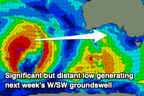
Now, into Wednesday, an inconsistent but strong, long-period W/SW groundswell is due to arrive, building into the afternoon.

The source is a very strong low in the Southern Ocean, currently sitting over the Heard Island region. This is producing storm-force winds in our far swell window and will slowly weaken while moving further east, closer towards Western Australia over the weekend before breaking down Monday.
The swell from this low should come in at a good but inconsistent 2ft across the Mid Coast Wednesday afternoon/Thursday while the South Coast looks slower and to 3ft+ or so. Winds are still a little tricky but a trough followed by high should bring S-S/SE winds on Wednesday, around to the E/SE Thursday, favouring the Mid Coast. More on this Monday. Have a great weekend!

