Good run of swell and winds for both regions
South Australian Surf Forecast by Craig Brokensha (issued Monday July 1st)
Best Days: South Coast tomorrow morning, Mid Coast Thursday, Friday and Saturday, South Coast Thursday and Friday mornings, South Coast Saturday, Sunday, Monday
Features of the Forecast (tl;dr)
- Moderate sized S/SW swell for tomorrow AM, easing, smaller into Wed
- N/NE tending E/SE-SE winds tomorrow, NE tending E/SE-SE Wed (E/SE-E winds on the Mid)
- Inconsistent W/SW groundswell for Thu, holding Fri AM ahead of a secondary pulse of more SW swell energy Sat AM
- NE tending E/SE-SE winds Thu and Fri (E/SE-E winds on the Mid)
- Moderate to fresh E/NE wind Sat/Sun (E winds on the Mid)
- Easing swell into early next week with N winds
Recap
A poor weekend of surf with dawn W’ly winds giving into a gust S’ly change quickly thereafter Saturday morning, remaining choppy and poor yesterday but with moderate levels of S’ly swell (tiny inside the gulf).
Winds have quickly improved this morning but there’s still a ton of lump in the water thanks to yesterday’s and overnight onshore winds, clean but tiny inside the gulf.
This week and weekend (Jul 1 - 6)
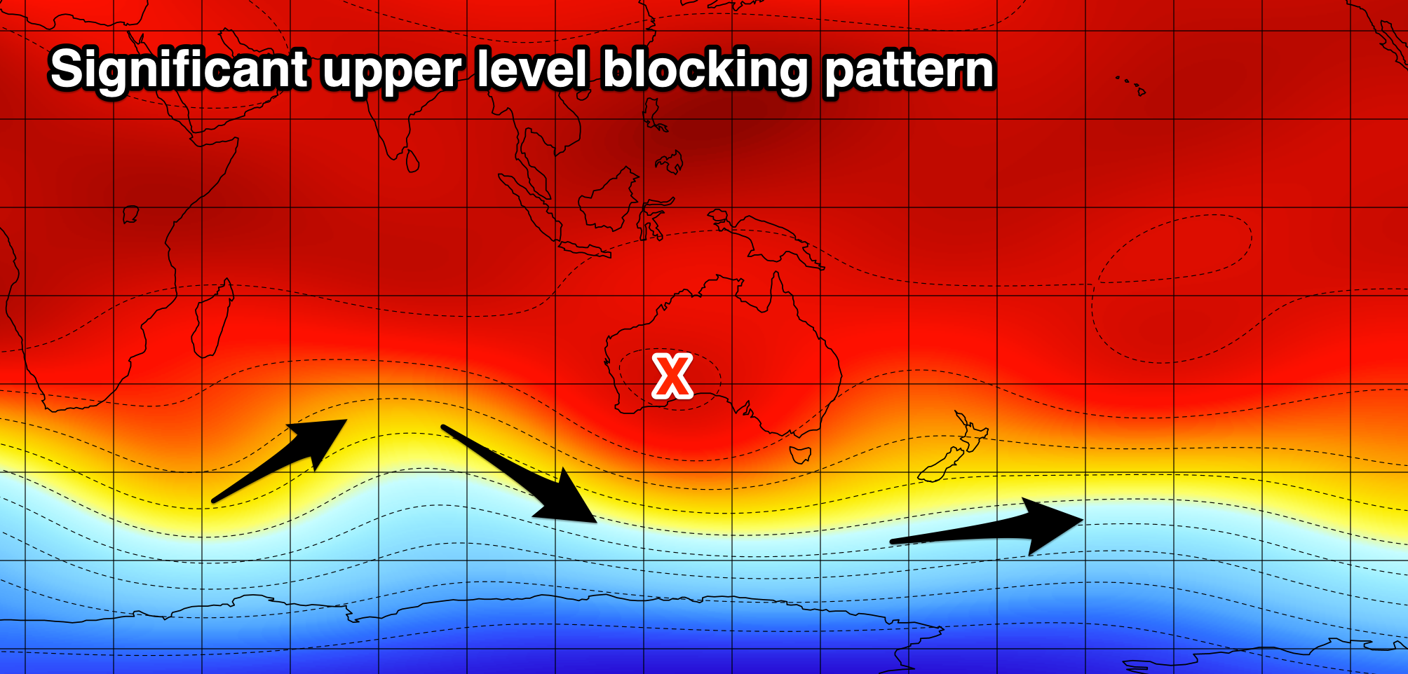
Following the weekend’s deepening low which has continued to travel east across to New Zealand, we’re looking at a very un-winter-like pattern for the first two weeks of July, if not longer.
This is thanks to a significant upper level blocking pattern setting up immediately west of us, deflecting any major frontal systems away from us. Instead we’ll see high pressure dominate the westerly storm track, while at the same time healthy looking fronts fire up in our medium-long range swell window, south of the Indian Ocean.

Firstly, over the coming days we’re set to see a signifcant high pressure slowly move in (possibly reaching 1045hPa), but stall under us, bringing a general easterly flow that will tend NE during the mornings and E/SE-SE into the afternoons (E/SE tending variable on the Mid Coast).
Tomorrow looks to see a better N/NE offshore and swell wise, our pulse of S/SW swell energy from polar frontal activity at the base of the trough that moved through yesterday should generate some fun size.
It’s due to arrive later this afternoon/evening and ease tomorrow, coming in at 3ft to occasionally 4ft across Middleton, tiny inside the gulf.
Wednesday will become smaller and be best across the magnets.
Into the end of the week and weekend, we’re set to see our inconsistent pulses of W/SW groundswell from the Indian Ocean moving in, the first for Thursday and more for Friday/Saturday.
The progression generating these swells has been downgraded a little but still healthy, with the strongest pulse of energy now looking to have a SW direction, generated by a fetch of gale to severe-gale W/NW winds moving in and under Western Australia, towards the polar shelf over the coming days.
This is due into late Friday afternoon but more so Saturday, peaking in the morning and then easing into the afternoon, Sunday and further next week.

Looking at the sizes, and the first pulse for Thursday should come in at an inconsistent 2ft on the favourable parts of the tide inside the gulf, building to 3-4ft across Middleton, holding Friday morning.
The stronger SW groundswell for later in the day but more so Saturday looks to come in at a stronger 4ft down South with infrequent 2ft sets continuing on the Mid Coast, fading Sunday.
Winds look a touch dicey for selected spots across the South Coast Saturday and fresher E/NE, holding all day, similar Sunday as the swell eases.
Next week as the swell eases should see great N/NE tending variable winds on Monday, with Tuesday seeing N/NW-NW winds, likely reverting back to the N’th on Wednesday.
The blocking effects of the high looks to result in a small run of swell, but we’ll review this Wednesday.


Comments
"a very un-winter-like pattern, thanks to a significant upper level blocking pattern west of us"
Is that more like autumnesque patterns??
Yep. Or even spring.
that would be right.....just started hols, almost two weeks of good conditions and swell prior.
Looks like a lot of E and not much N in the wind models...