Poor weekend, better windows opening up to next week
South Australian Surf Forecast by Craig Brokensha (issued Friday June 28th)
Best Days: South Coast today, South Coast Tuesday morning, Mid Coast later next week
Features of the Forecast (tl;dr)
- Inconsistent SW groundswell this afternoon and tomorrow, easing
- Early W/NW winds, shifting strong S by mid-AM
- Moderate sized, weak S swell Sun with gusty S-S/SE winds
- Easing weak swell Mon with E/NE tending SE winds
- Moderate sized S/SW groundswell Tue AM, easing with N/NW tending S/SE winds
- Easing swell Wed with moderate E/NE tending S/SE winds
- Moderate-large pulses of W/SW groundswell from Thu through Sat next weekend with winds unsure
Recap
The Mid Coast offered small, fading wind affected waves yesterday, tiny today and still under the influence of northerly winds. The South Coast has been the pick with less consistent but good 2-3ft waves yesterday, down to a slower 2ft this morning.
This weekend and next week (Jun 29 - Jul 5)
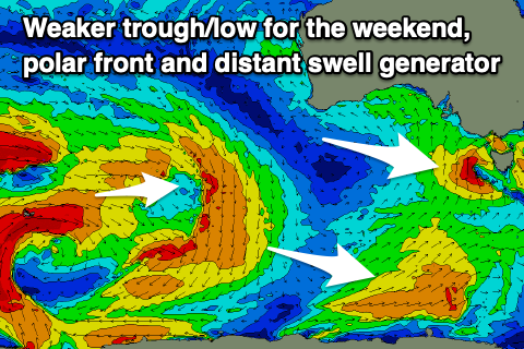
The weekend ahead looks fairly average for surf now with deepening mid-latitude low that was expected to stall south of us now coming in weaker and moving faster east.
It will act more like a trough with the swell potential downgraded along with poor winds for the South Coast.
Looking at tomorrow first though and an inconsistent SW groundswell that’s pinged on the Cape du Couedic wave buoy will offer inconsistent 2ft waves tomorrow, easing through the day. Unfortunately the window for clean conditions looks only to be at dawn thanks to the faster transition of the trough east, with a W/NW breeze due to shift strong S’ly mid-morning.
We’ll then see poor, gusty S/SE winds into Sunday along with some low quality swell from the low, with it being lucky to reach 3-4ft across the South Coast, tiny inside the gulf.

We should see winds tend lighter E/NE into Monday morning but with lumpy, weak easing surf from the 3ft range down South, tiny on the Mid Coast.
Later in the day Monday and more so Tuesday, some OK S/SW groundswell is due, generated by a healthy polar frontal system at the base of the trough moving through on the weekend.
Middleton should see 3-4ft sets Tuesday morning, easing through the day and then smaller into Wednesday with no size inside the gulf.
Tuesday looks best with a N/NW offshore ahead of S/SE sea breezes, moderate E/NE on Wednesday as the swell bottoms out.
As touched on in Wednesday’s notes, some inconsistent long-range W/SW groundswell is due later week, the first for Thursday likely followed by some stronger energy Friday/Saturday.
This will be generated by a strong Southern Ocean frontal progression pushing across the Heard Island region from today through the weekend and further east, towards Western Australia during next week.
Moderate to possibly large levels of swell are W/SW swell are due, likely to 2ft to maybe 3ft on the Mid Coast and in the 4ft+ range down South. Winds are still a little tricky so check back here on Monday for the latest. Have a great weekend!

