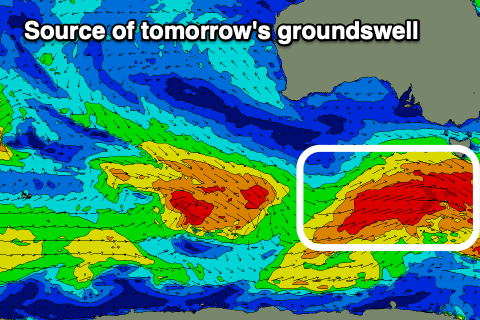
Strong south swells inbound
South Australian Forecast by Craig Brokensha (issued Wednesday May 15th)
Best Days: Tomorrow South Coast, early Friday South Coast, early Sunday South Coast
Features of the Forecast (tl;dr)
- Moderate + sized S/SW groundswell for tomorrow with local offshore winds ahead of sea breezes
- Easing swell Fri with early, local offshore winds, shifting S/SW and strengthening later AM, back to the S/SE later PM on the Mid
- Moderate + sized S/SW groundswell Sat AM, easing Sun
- Mod-fresh E/SE tending S/SE winds Sat, variable tending S/SW-SW winds mid-AM Sun
- Moderate sized mid-period S/SW swell Mon with S/SW winds
- Smaller Tue with fresh S/SE-SE winds
- Possible S'ly groundswell Wed with E/NE tending S/SE winds
Recap
Monday’s good pulse of W’ly energy eased back from 1-2ft yesterday on the Mid Coast with light winds all day, while the South Coast was a fun 3ft on the sets with conditions also remaining good into the afternoon.
Today we’ve got tiny leftovers on the Mid and small, clean 2ft sets across the South Coast.
This week and next (Apr 16 - 24)
The weak energy currently breaking on the coast will be replaced by much stronger and bigger pulses of swell over the coming days thanks to an active Southern Ocean storm track under the country.
The first of these formed under the country yesterday and we’re seeing a great fetch of strong to gale-force W/NW winds followed by similar strength W/SW winds, generating a moderate + sized pulse of S/SW groundswell for tomorrow, pulsing to 4-5ft across Middleton with the Mid Coast likely to kick to 1-1.5ft

Right on the back of this initial frontal system will be a stronger polar low through today and tomorrow, with fetches of gale to severe-gale W/SW winds due to be generated later through our southern swell window.
This should generate a secondary similar pulse of groundswell for late Friday but more so Saturday morning coming in at 4-5ft across Middleton again, with the possible rare bigger one in the mix, easing into the afternoon and further Sunday. The Mid should persist around the 1ft range.
But coming back to tomorrow and conditions should be great across both locations with an E/NE offshore wind on the Mid, NE-N/NE down South ahead of sea breezes.
Friday looks dicey as a trough starts to move in, but early, light local offshore winds are due before shifting S/SW and strengthening from late morning, tending S/SE across the Mid later afternoon.

Unfortunately moderate-fresh E/SE winds are expected on Saturday morning with the secondary pulse of S/SW groundswell, with Sunday likely to see early W/NW winds before another trough brings a shallow SW-S/SW change mid-morning.
The frontal system linked to this change is due to generate some new mid-period S/SW swell for later Sunday but more so Monday, though size wise it looks to be in the 3ft+ range across Middleton, tiny on the Mid Coast along with S/SW winds.
Tuesday will see fresh S/SE-SE winds, possibly starting to improve and tending E/NE through the mornings on Wednesday, but this depends on the movement of a high in from the west later week.
Swell wise, a small-moderate sized pulse of S/SW groundswell is on the cards for Wednesday, with another possible swell for later week. We’ll look at this closer Friday.

