Great couple of days for the South Coast
South Australian Surf Forecast by Craig Brokensha (issued Monday December 11th)
Best Days: Late today South Coast, tomorrow, Wednesday and Thursday morning South Coast, Sunday morning South Coast
Features of the Forecast (tl;dr)
- Easing S/SE windswell today with easing SE winds, tending fresh W/NW-NW in the last couple of hours before dark
- Large S/SW groundswell building rapidly tomorrow with W/NW-NW winds ahead of weak sea breezes
- Easing swell Wed with strengthening N/NW winds, tending W/NW later
- Small, fading swell Thu with W/NW winds, tending SW into the PM
- Small reinforcing S/SW groundswell Thu PM, easing Fri
- W/NW tending S/SW winds Fri, similar Sat
- Small mid-period SW swell Sun with E/NE-NE tending SE winds
- Moderate sized, mid-period W/SW-SW swell for Mon-Tue next week with S/SE-SE winds
Recap
Generally poor surf on the weekend with tiny waves for beginners on the Mid, small and onshore down South.
Today winds have really picked up thanks to a deepening low developing to our west, and with this we've seen a localised chunky S/SE windswell whipped up across the South Coast (tiny to flat on the Mid Coast).
We've got a funky day of weather and winds due thanks to the low moving further south, and this should see the waves improve rapidly on dark. Read on below for more details.
This week and weekend (Dec 12 - 17)
Currently the state is under the influence of a broad area of low pressure that's sitting from Adelaide through to the Bight, squeezing a high to the south.
The area of low pressure is expected to shift south during this evening and this should bring easing winds from the SE that are due to shift fresh NW right on dinner time, cleaning up the sizey, easing S/SE windswell that's currently in the water.
Locations around Victor should offer fun surf for the keen and flexible.
Moving into tomorrow, light to moderate W/NW-NW winds should persist across the South Coast, only giving into weak sea breezes as our strong, large S/SW groundswell fills in.
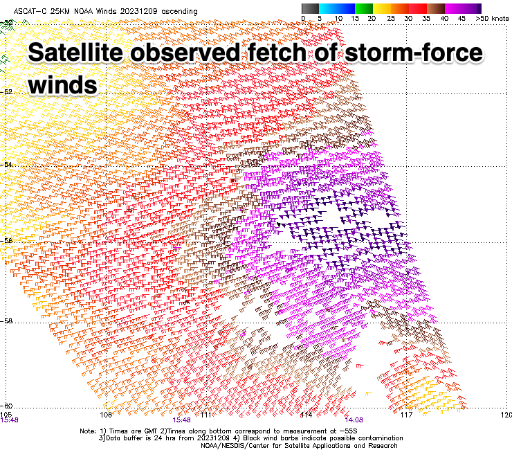
This swell was generated by a great storm that fired up to the south-west of Western Australia late last week. This low generated a fetch of severe-gale W/NW tending W winds while pushing east through our south-western swell window and is now weakening while passing under Tasmania. There were even a few storm-force barbs registered by satellite (below left) and this should see a strong spike in size through the day down South, pulsing to 5-6ft across Middleton and 6ft on the deepwater reefs, tiny across the Mid Coast.

With the favourable local winds most of the day, there'll be plenty of time to get a few sessions in.
Wednesday will be great as the swell eases from the 4ft range across Middleton under strengthening N/NW winds, shifting W/NW later ahead of a mid-latitude frontal system.
The front isn't due to cross us until Thursday afternoon, so this will see clean conditions persisting in protected spots during the morning but with smaller 2ft to possibly 3ft leftovers.
A small pulse of reinforcing S/SW groundswell is due into the afternoon Thursday, generated by a small, tight but strong low forming on the tail of the system linked to tomorrow's swell. Sets to 3ft should be seen across Middleton, easing Friday.
Winds should tend back W/NW on Friday morning ahead of S/SW sea breezes, with similar winds on Saturday but small surf. Sunday looks OK with some new, mid-period SW swell with a morning E/NE-NE breeze.
Longer term, a healthy frontal system moving in from the west should generate some fun W/SW swell for early next week with what looks to be favourable winds for the Mid Coast out of the south-eastern quadrant. More on this Wednesday.


Comments
Sunday looking ok down south?
Yep, mid-period swell should be 2-3ft off Middleton with E/NE-NE morning winds.
noice thanks!