Trickier period, best on the South Coast from Sunday
South Australian Surf Forecast by Craig Brokensha (issued Friday August 4th)
Best Days: Tomorrow morning Mid Coast, South Coast Sunday, Monday, Tuesday and Wednesday, (Tuesday PM for the keen on the Mid)
Features of the Forecast (tl;dr)
- Easing W/SW swell on the Mid Coast tomorrow with S/SE tending S/SW winds
- New moderate sized close-range S/SW swell down South with fresh S/SW tending weaker S/SE winds
- Easing swell Sun with light offshore winds and weak sea breezes
- Moderate sized, long-period S/SW groundswell building later Sun, peaking Mon AM with light local offshore winds and weak sea breezes
- Easing swell Tue with light, local offshore winds, variable into the PM
- Small-mod sized, inconsistent W/SW swell for Tue PM, easing Wed
- Fresh N/NE tending N/NW winds Wed
Recap
Dropping surf with windy, choppy conditions across the Mid Coast while the South Coast was best in the morning ahead of wind affected surf into the afternoon.
Today a mix of new W/SW groundswell and SW swell energy are filling in but with strong W'ly winds and poor weather. It's a lay day for most.
This weekend and next week (Aug 5 - 11)
A strong mid-latitude low is currently moving in and across us, bringing a S/SW change to all locations tomorrow, easing and tending more S/SE through the day. The Mid Coast should see a morning S/SE breeze and we'll see easing 1-2ft sets on the Mid Coast while the South Coast should see some new mid-period S/SW swell to 3-4ft.

Sunday looks cleaner down South with a light N/NW offshore wind but easing 2-3ft of S'ly swell, tiny on the Mid Coast.
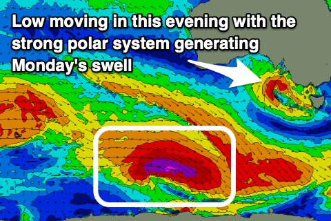
Later in the day we may see new sets linked to Monday morning's SW groundswell arriving, with it generated by a strong polar low that formed east of the Heard Island region yesterday.
The core wind speeds have been upgraded, with gale to severe-gale W-W/NW winds sitting right on the polar shelf (even a couple of storm-force barbs registered), though weakening into this afternoon while continuing to track east-southeast.
This will produce a moderate sized, long-period S/SW groundswell that should kick late Sunday along with weak sea breezes, peaking Monday to a strong 4ft+ across Middleton, though tiny and to 1ft on the Mid Coast thanks to the southerly direction.
Winds look great with light local offshore breezes Monday morning, giving into weak afternoon sea breezes, similar Tuesday but possibly more variable into the afternoon with easing 2-3ft sets down South.
A small to moderate sized, inconsistent W/SW swell is due to arrive Tuesday afternoon, generated by a distant fetch of W/SW winds moving through the southern Indian Ocean.

It'll be inconsistent and offer no major size but the Mid Coast should see 1-1.5ft sets into the afternoon, easing from a similar size on Wednesday, with 2ft+ sets across Middleton.
With the variable afternoon winds on Tuesday it'll be worth a look on the Mid while stronger N/NE tending N/NW winds will move in Wednesday as the swell eases.
Now, as touched on last update, the outlook for the rest of the week is slow with no significant swell generating storms expected to form close to the Australian continent.
A renewal of Southern Ocean fronts will hopefully be seen later week/next weekend but we'll review this Monday. Have a great weekend!

