Strong swells for the coming days with decent winds
South Australian Surf Forecast by Craig Brokensha (issued Monday July 31st)
Best Days: Today South Coast (Mid Coast for the keen), both coasts tomorrow, South Coast Wednesday, South Coast Sunday and Monday
Features of the Forecast (tl;dr)
- Mod-large SW groundswell for tomorrow, easing later and further Wed
- Easing W/SW swell on the Mid
- Early E/NE-NE tending N/NE then N/NW winds on the Mid, variable later
- NW tending variable winds down South
- Freshening N/NE tending N/NW winds Wed
- Small, fading surf with strong N/NW winds
- Moderate sized + W/SW groundswell for Fri with strong SW winds, easing Sat with mod-fresh SW winds
- Possible new SW groundswell building Sun with N/NW tending W/NW winds
Recap
Tiny waves across the Mid Coast on Saturday while a new W/SW swell provided a kick to 2ft yesterday with workable morning winds, deteriorating through the day.
The South Coast was biggest Saturday morning with a S/SW swell to the 3ft range, a bit under the expected 3-4ft, 2-3ft on Sunday with a reinforcing W/SW swell. Conditions were great all weekend with persistent offshore winds.
Today we've got a lift in moderate to large mid-period swell coming in at 2-3ft on the Mid Coast and 4ft+ down South with clean conditions in protected spots under strong W/NW winds.

Overhead sets in the Bay this AM (note the surfer on the left)

2-3ft on the Mid Coast this morning
This week and weekend (Aug 1 - 6)
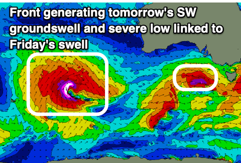
Today's moderate to large mix of W/SW swells will be backed up by a stronger pulse of SW groundswell tomorrow morning, generated by a final embedded front in a strong progression that we've seen take place since late last week.
This final front is generating a fetch of severe-gale W'ly winds to our south-west today and this should provide an additional boost in size tomorrow to 6ft on the sets across the Middleton stretch while the Mid Coast should ease from 2ft to occasionally 3ft on the favourable parts of the tide, smaller and down from 1-2ft on Wednesday.
The South Coast looks to still be solid Wednesday morning and easing back from 4-5ft.

Local winds will favour both coasts tomorrow though be best for the South Coast with a NW offshore, E/NE-NE on the Mid but tending N/NE quickly and then N/NW before becoming variable into the mid-late afternoon. This will see conditions be best early and late on the Mid Coast.
Wednesday will see freshening N/NE tending N/NW winds, creating great conditions all day down South, stronger Thursday from the N/NW ahead of an approaching trough.
Unfortunately this trough will move through just before dawn on Friday bringing strong SW-S/SW winds to all locations as a moderate sized + W/SW groundswell peaks, generated by the initial stages of the trough (that being between Heard Island and Western Australia today).
As touched in Friday's update, its structure isn't ideal for swell production for us with it being aligned more south to north and aimed into Indonesia, but with wind speeds of severe-gale to storm-force S/SW winds, weakening while aiming more SW and into our swell window.
The swell is due to peak Friday, coming in at 2ft+ on the Mid Coast with the South Coast seeing 4-5ft sets but with those poor winds.
Saturday unfortunately looks to see persistent SW winds but with less strength, possibly tending S/SE early on the Mid and W/NW down South but we'll review this on Wednesday.
Sunday does look cleaner with local offshores across both coasts along with a possible new SW groundswell. Following this, next week looks a bit funkier and not as reliable. More on this Wednesday.

