Make the most of the coming days
South Australian Surf Forecast by Craig Brokensha (issued Wednesday December 22nd)
Best Days: This afternoon/evening Mid Coast, beginners on the Mid Coast Thursday, South Coast Friday morning, next Thursday South Coast
Features of the Forecast (tl;dr)
- Easing mix of SW swells tomorrow with moderate E/SE tending S/SE winds
- Easing S/SW swell Fri with NE tending S winds
- Poor weekend with gusty S/SE winds Sat, stronger from the SE tending S/SE Sun with a building S/SE windswell
- Mid-period S/SW swell Mon with gusty SE tending strong S/SE winds
- Small, mid-period S/SW swell Thu with variable tending S/SE winds
Recap
Monday afternoon's pulse of swell to 2-3ft on the Mid Coast eased back to a smaller, less consistent 2ft yesterday morning with variable winds and clean conditions. The afternoon provided more consistency and the sea breeze wasn't too bad while this morning we've got great conditions but slower 1-2ft sets.
The South Coast was clean and fun to 3ft off Middleton yesterday morning but conditions deteriorated into the afternoon. Today there was more size on offer but conditions are bumpy with a moderate to fresh S/SE breeze. We should see larger sets building through the day as the strongest of the swell from the past few days fills in.

Small waves this morning
This week and weekend (Dec 23 – 26)
As the largest pulse of SW groundswell fills in this afternoon we should see the Middleton stretch pushing to 4-6ft, while the Mid Coast should offer 2ft sets with the incoming tide. Conditions will be bumpy across the South Coast but remaining clean on the Mid with S/SE-SE winds (well worth a paddle).
Into tomorrow morning we'll see the mix of mid-period and groundswell energy easing across the state, dropping back from 4-5ft across Middleton and 1-1.5ft on the Mid Coast.
Conditions will unfortunately remain bumpy down South with a moderate E/SE breeze, shifting S/SE through the day while the Mid Coast will be super clean and remaining so most of the day.
 The South Coast is looking much better Friday with winds due to shift NE with a further drop in mid-period S/SW swell from 3ft on the sets across Middleton. The Mid Coast will be clean but tiny to flat. A trough will bring a S'ly change early afternoon and following this conditions will be poor for the coming weekend.
Therefore make the most of the cleaner conditions Friday morning as a high moving in from the west and a deepening trough off the East Coast will see a squeezing southerly pressure gradient through the weekend. This will bring strong S/SE winds on Saturday as the swell reaches a low point, stronger SE tending S/SE on Sunday with some new S'ly windswell.
Unfortunately this high will stay stubbornly south-west of us through next week resulting in persistent winds from the south-eastern quadrant but no decent swell for the gulf, which will be clean.
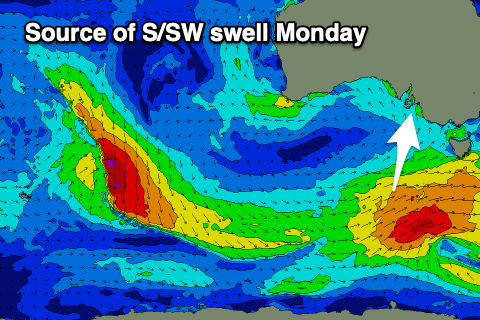
 Swell wise, a small, mid-period S/SW swell should be in the water Monday, generated by a strengthening polar frontal progression south-west of Tasmania over the coming days. This should generate 3ft of swell for Monday, but there'll also be S/SE windswell in the mix, disguising the better quality swell.
We may see a smaller S/SW swell for Thursday as winds go more variable in the morning, but besides this the outlook looks slow into the New Year as high pressure dominates and the tropics get active. More on this Friday.

