Fun swell pulses for the Mid though watch the winds
South Australian Surf Forecast by Craig Brokensha (issued Wednesday December 15th)
Best Days: Mid Coast for the keen tomorrow and more so Friday, South Coast Friday, both coasts early Sunday and Monday mornings, Mid Coast mid-next week
Features of the Forecast (tl;dr)
- E/NE morning winds tomorrow with an inconsistent SW groundswell building into the PM, easing Fri with E/NE-NE tending variable winds on the Mid, N/NE tending NE and possibly variable down South
- Small reinforcing W/SW swell Fri
- Moderate sized, inconsistent W/SW groundswell building Sat with strong but abating SW winds (possibly W/NW early down South), peaking Sun with early variable tending W/SW winds
- Reinforcing W/SW swell Mon with similar winds to Sun
- Large SW groundswell likely for mid-next week
Recap
Our new mid-period W/SW tending SW swell expected through yesterday afternoon came in a little early, with fun, close-spaced 1-2ft sets through the morning, clean until sea breezes kicked in, then improving again late in the day. The South Coast was small and bumpy, building through the afternoon but with onshore winds.
Today the swell has eased back to a clean 1-1.5ft on the Mid Coast with the South Coast offering workable 2-3ft sets across Middleton.

Mid-period swell with its signature close-spaced sets
This week and next (Dec 14 – 24)
The coming outlook remains fun and decent for the Mid Coast while there are a couple of windows for a surf down South.
The swell seen yesterday and today will fade into tomorrow morning with our new, inconsistent SW groundswell due to arrive through the day and build into the afternoon.
The source of this swell was a distant polar low south-east of South Africa. This swell won't be as good as yesterday's on the Mid with inconsistent 1-1.5ft sets due into the afternoon, holding Friday with a weaker, mid-period reinforcing swell. The mid-period energy on Friday looks more consistent.
Down South tomorrow looks to start around 1-2ft with building sets to 2-3ft later in the day, easing back Friday from 2ft to possibly 3ft.
Winds will improve for the South Coast tomorrow and tend E/NE during the morning (E/SE-E on the Mid Coast) ahead of sea breezes. Friday will be the best down South with a N/NE offshore and weak, possibly variable sea breezes, (ENE-NE on the Mid Coast and variable into the afternoon).
 These favourable winds will be ahead of a trough and strong SW change early Saturday creating poor conditions both coasts as the swell drops further. There's an outside chance of early W/NW winds down South but it'll be small.
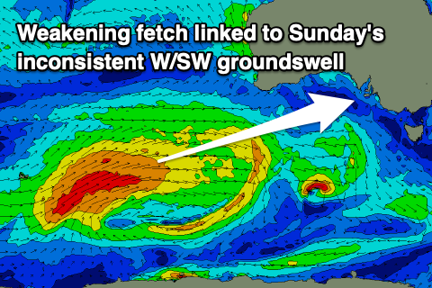
Of greater importance is the better W/SW groundswell due into Saturday afternoon and more so Sunday. This was generated by a healthy frontal progression and polar low firing up from the Heard Island region, towards Western Australia the last couple of days. It's now weakening south-west of Western Australia but continuing to aim W/SW winds through our swell window and we'll see a good, consistent mix of mid-period and longer-period groundswell with an increase to 1-2ft due Saturday afternoon with Sunday seeing 2ft waves.
 Middleton should kick later Saturday but peak Sunday to 3-4ft across Middleton. Winds on Sunday now look dicey and possibly variable early before increasing from the W/SW as another front moves in from the west, while the South Coast should be fun with W/NW tending W/SW-SW breezes.
Similar winds are due on Monday and the front bringing the westerly winds should produce some reinforcing W/SW swell to 2ft on the Mid Coast and 3ft across Middleton.
Of much greater importance is the upgrade in a polar low that's due to form south-west of Western Australia on the weekend. The American model has this low being much stronger and bigger in scope than the European global forecast models but either way we're looking at a strong SW groundswell for the middle of the week. Winds at this stage look favourable for the Mid Coast and out of the south but more on this Friday.

