Poor end to the week, better weekend
South Australian Surf Forecast by Craig Brokensha (issued Wednesday December 8th)
Best Days: South Coast Saturday and Sunday mornings, South Coast Wednesday morning, Mid Coast next Friday
Features of the Forecast (tl;dr)
- Mix of mid-period SW and S/SE windswell with gusty S/SE winds (possibly more SE early)
- Smaller Fri AM with moderate SE tending fresh S/SE winds
- Late pulse of new S/SW groundswell Fri, easing Sat with E/NE tending S/SE winds
- Slow easing, mid-period S/SW swell Sun with N/NE tending SE winds
- Smaller Mon with SW winds, bottoming out Tue with variable tending S winds
- Inconsistent W/SW groundswell next Fri with S/SE winds
Recap
Tiny, windswelly waves across the Mid Coast yesterday with average cross-onshore winds, small and choppy down South.
Today there's a touch more energy on the Mid as expected with a little kick in swell, coming in at a cleaner 1ft, poor and sloppy 2-3ft down South with a slightly more workable E/SE morning breeze.
This week and weekend (Dec 9 – 12)
There's no change to the outlook into the end of the week with gusty S/SE winds due to persist tomorrow across the South Coast, possibly being more SE at periods through the morning.
The Mid Coast will be clean but today's tiny swell is due to ease back from 0.5-1ft. The South Coast will see some inconsistent, mid-period SW swell but localised S/SE windswell looks to be more consistent and to 2-3ft across Middleton.
 Friday will see winds ease off a little but remain moderate from the SE through the morning, freshening from the S/SE into the afternoon.
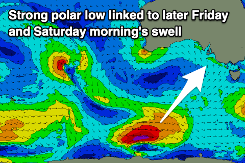
Later in the day we should see a new S/SW groundswell filling in, with this swell being upgraded slightly since Monday.
The source of this swell is a polar low that formed south of Western Australia yesterday, with a tight fetch of gale to severe-gale W'ly winds being generated overnight, weakening today as it pushes further east.
This will produce a decent S/SW groundswell that should kick to a good 3ft+ across Middleton late in the day, easing from a similar size Saturday morning. It'll be too south in nature to get into the Mid Coast.
Winds should start to slowly improve on the weekend as a high slides east under us, bringing an E/NE breeze Saturday morning and peaky, fun waves across select locations down South ahead of S/SE sea breezes kicking in early afternoon.
Sunday will be even cleaner with a N/NE offshore and weak sea breezes as the S/SW energy eases further from 2-3ft across Middleton. This easing trend will be slowed slightly by a secondary, reinforcing S/SW swell from a weaker polar front trailing the initial polar low.
 Make the most of the clean, peaky waves as another trough will move in Monday morning, bringing a SW change just before dawn. We may see winds tend more variable again into Tuesday morning but swell wise, there's not due to be much left in the tank.
Wednesday morning looks a better chance for a light NE breeze before the next trough moves in and there should also be a weak new, mid-period SW swell in the mix.
Of greater significance is an inconsistent W/SW groundswell for later in the week along with S/SE winds across the Mid Coast, but we're only looking at surf to 1-2ft at this stage. More on this Friday.

