Pencil a surf in early-mid next week
South Australian Surf Forecast by Craig Brokensha (issued Friday November 26th)
Best Days: Monday morning South Coast, Tuesday South Coast, Wednesday morning South Coast, late Thursday and Friday on the Mid Coast
Features of the Forecast (tl;dr)
- Easing moderate sized S/SE windswell tomorrow with strong SE tending S/SE winds, smaller Sun with light to moderate E/SE tending fresh S/SE winds
- Small, SW swell for Mon with variable offshore tending S/SE winds
- Better, mid-period SW swell building Tue with N/NE tending NW winds, holding Wed with N/NE tending S/SW winds
- Building W/SW swell later Thu, peaking Fri with S/SE winds
Recap
Poor surf all over with a strong onshore wind and junky, solid increase in windswell on the South Coast, even bigger today. The Mid has offered tiny, wind affected waves to 0.5-1ft best suited to the beaches around the lower tides.
This weekend and next week (Nov 27 – Dec 3)
The weekend will see a continuation of poor winds and surf as winds remain strong from the SE tomorrow along with a slight drop in S/SE windswell, smaller Sunday as winds back off and tend lighter E/SE through the morning. This is thanks to a developing low in the Tasman Sea, squeezed by a high pressure system south-west of us.
Conditions will still be all over the place Sunday, even with the lighter winds, with the lack of offshore wind to clean it up so don't expect anything special at all Sunday morning.
Early-mid next week is looking much better as we see an inland trough/low interacting with a high sliding slowly east, swinging winds around to the north-eastern quadrant.
Swell wise, a small, mid-period SW swell is due Monday ahead of some better SW energy Tuesday afternoon and Wednesday.
 Monday's swell is being generated today by a weak front passing under the country, with small, slow 2ft sets due across Middleton (tiny to flat on the Mid Coast).
Tuesday and Wednesday's swells will be better, but they look a little weaker than expected in the last update with the pre-frontal, swell generating fetch of W/NW winds moving in from the west being more drawn out, faster moving and not quite as strong.
The first pulse of swell will build Tuesday and reach 2ft to occasionally 3ft across Middleton into the afternoon, with tiny 0.5-1ft sets on the Mid Coast, holding most of Wednesday.
Winds look good with a variable, light local offshore wind due Monday morning ahead of S/SE sea breezes, better Tuesday and Wednesday with N/NE tending NW winds on the former and N/NE winds Wednesday morning ahead of a trough and S/SW change early afternoon.
 This trough will likely be followed by a high and strengthening S/SE winds into the end of the week, but a fun new mid-period W/SW swell should be in the water.
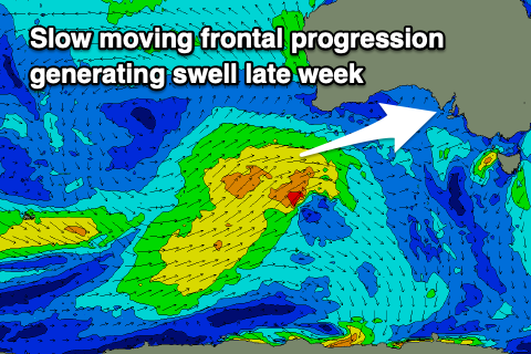
The trough will spawn off a broad, slow moving polar frontal progression that will begin its life around the Heard Island region this weekend, moving slowly east through early to mid-next week.
This will see a moderate sized, prolonged mid-period W/SW swell generated, arriving later Thursday but filling in further Friday, easing slowly Saturday. The Mid Coast will hopefully see 1-2ft sets, with 4ft waves down South but we'll have a closer look at this on Monday. Have a great weekend!


Comments
Hey Craig. I've seen photos of a massive amount of blue bottles washed up at Basham Beach at Middleton on Thursday. Not sure I've seen such a congregation in SA waters before. Any thoughts?
Wow really, that's a rare one. Got a link to it?
I don't mate. They're jpgs. But if you have an email I can send a couple to you.
Yeah try craig@swellnet.com
Slightly off topic, but I’ve always wondered what the jellyfish are that you see over summer sometimes at W&P. Smallish with some black on them but clearish too. Haven’t seen them anywhere else on the south coast.
You're not thinking of salps?
Craig, not sure if that was directed at me or miwlkim, but that's not them. Fairly "standard" looking jellyfish but look a bit nasty because of the colour.
Agh, yeah that was for you.
Here is a Vid I got from some go pro footage above November last year just of the point at W&P
The video was all scrambled stuff but if you view about 1.15 min you can see the dark looking jellies
Yep that’s them! Must be someone on here that can identify them?
Yes, there were many. Likely ID = Velella velella all the way down towards the Murray Mouth
Just seen the shots, without stingers it looks?
Yep, all under 2 centimetres apparently (except one larger one) and I can't see any stingers. Most have washed back out to sea now.