Fun run of swells with favourable conditions
South Australian Forecast by Craig Brokensha (issued Friday 4th September)
Best Days: Both coasts tomorrow, early Sunday Mid Coast, South Coast all day, Wednesday Mid Coast, Thursday both coasts
Recap
Strong winds and choppy, building surf on the Mid Coast yesterday, better today and to 2-3ft for the keen with northerly winds.
The South Coast was average with the strong wind yesterday and small swell, much better today and to 3ft across Middleton with a lighter offshore wind.

This weekend and next week (Sep 4 – 11)
Today's mix of mid-period W/SW swells will ease back through tomorrow, but it'll be replaced by some new inconsistent W/SW groundswell from a strong low that formed east of the Heard Island region earlier this week and projected north-east towards Western Australia.
This and then a follow up low moving in behind it from the west should keep the Mid Coast topped up with inconsistent waves through the weekend, with the size easing on the South Coast from tomorrow morning.
Inconsistent 2ft to occasionally 3ft sets are due across the Mid Coast tomorrow, dropping back to 2ft Sunday while the South Coast should see 3-4ft sets across the Middleton to Goolwa stretch in the morning tomorrow, easing a little later in the day and then back from 2-3ft on Sunday.
Locally winds should improve all weekend with tomorrow morning seeing light W/NW-NW winds down South, shifting onshore through the day but without much strength, while the Mid should see light variable winds from the north early, and weak onshore winds through the day.
Sunday will be best early on the Mid with a NE breeze, quickly swinging N-N/NW and freshening, great all day down South.
 Stronger N/NE winds will kick in on Monday but with the small, fading swell the South Coast magnets are the only option though tricky with the strength of the wind.
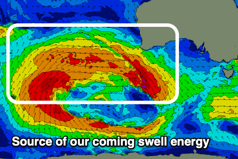
Later in the day but more so from Tuesday some new W/SW groundswell energy should start to fill in, generated by a broad, strengthening and slow moving storm that's currently drawn out from a position west of Western Australia to the polar shelf.
We'll see tricky fetches of strong to gale-force W/SW-W winds generated through our western swell window, favouring the Mid Coast over the South Coast. The progression will move slowly east through the weekend and then under WA and into the Bight on Monday, weakening once clipping us Tuesday.
Some mid-period W/SW energy should build Tuesday ahead of the groundswell on Wednesday, but keep in mind the South Coast models are over-forecasting the expected size.
 The Mid Coast should build slowly to 2ft through Tuesday with Wednesday seeing 2ft to occasional 3ft sets. The South Coast should build slowly Tuesday but only to 2-3ft into the afternoon across Middleton, better Wednesday and more so to 3ft, with the odd bigger one towards Goolwa. It'll be inconsistent so expect long waits between sets.
Now, a trough will move through Tuesday bringing an onshore south-west change to all locations, great on the Mid Coast and offshore from the SE on Wednesday. Thursday will be best down South as the swell eases under a NE offshore.
Longer term there's more westerly swell due into next weekend, but more on this Monday. Have a great weekend!

