Plenty of swell coming for the South Coast, but winds?

South Australian Forecast by Craig Brokensha (issued Wednesday 18th March)
Best Days: Desperate surfers Mid Coast Friday afternoon, keen surfers South Coast Saturday morning and Monday morning
Recap
Good waves across the South Coast yesterday, best on the magnets while tiny and bumpy on the Mid Coast, tiny today down South with the odd small one on the magnets for the desperate.
This week and next (Mar 19 - 27)
We're looking at similar clean but tiny surf tomorrow morning down South but with a stronger offshore wind, likely blowing out any leftover wave. Winds are due to shift from N/NE to N/NW ahead oh a shallow change, likely holding W/NW until late but with no new swell. The Mid Coast will be bumpy with a tiny windswell.
Friday morning will be clean again with a W/NW offshore but the swell will remain tiny most of the day ahead of a very late pulse of S/SW groundswell. This S/SW groundswell will be a good long-period number, but the arrival looks to be overnight and into Saturday morning.
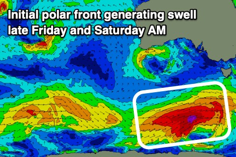 Currently a strengthening polar front is developing south of WA, with a fetch of strengthening gale to severe-gale W/SW winds due to project east-northeast through our southern swell window today before moving out of our swell window tomorrow morning.
This should produce a moderate sized S/SW groundswell, building late Friday to 2-3ft off Middleton, but with a S'ly change, peaking Saturday morning to 3ft to occasionally 4ft off Middleton. Winds are looking a little better and likely E-E/NE through the morning creating workable waves for the keen ahead of sea breezes.
But coming back to the Mid Coast for a second, Friday will see an increase in new W/SW swell from a weak mid-latitude low moving in from the west, but size wise I wouldn't expect anything over 1-1.5ft though conditions will improve into the afternoon as winds shift to the south. Saturday will be clean but only 0.5-1ft or so.
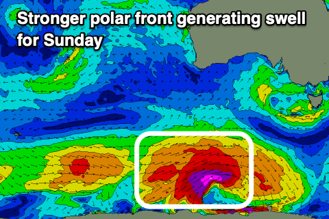 Moving into Sunday and a stronger S/SW groundswell is due on the South Coast, generated by a broader and and stronger polar low firing up south-southwest of WA tomorrow morning, generating a great fetch of severe-gale to storm-force W/SW winds through our south-western and then southern swell windows.
The swell should arrive through Sunday morning and spike through the afternoon, building to 4-5ft+ across Middleton, but tiny on the Mid Coast owing to the swell source and direction.
Conditions will unfortunately be average with a moderate S'ly tending fresh S/SE breeze as a strong high moves in from the west, with Monday seeing slightly more favourable E/SE breezes as the swell eases through the day.
Secondary pulse of S/SW groundswell more in the medium sized range are due through Tuesday and Wednesday but with persistent winds from the southern quadrant and no size for the Mid Coast. This is due to the node of the Long Wave Trough bringing the fronts and swells pushing further east, which results in those poor onshore winds instead of workable westerly breezes.
Comments
At last, some swell for the weekend:it may be windy but who cares. Love your work swellnet.
Got to be one of the worst periods of no decent waves for many years! Probably only been a few days worth surfing over the last 6 weeks or so. Been more like what we would normally get in November and early December. Got to end soon!