Plenty of swell from the south-west but winds remain a problem
South Australian Forecast by Craig Brokensha (issued Monday 24th February)
Best Days: Keen surfers South Coast tomorrow, Thursday down South, Friday down South, Saturday and Sunday mornings down South
Recap
Tiny to flat and clean waves on the Mid Coast all weekend while the South Coast offered cleaner options, but the swell bottomed out into Sunday leaving the odd small one at the swell magnets.
Today a new mix of SW groundswell and mid-period SW swell are on the build with nice clean conditions and surf to 3ft off Middleton, 1ft on the Mid and with a peak due this afternoon. We should see sets to 3-4ft across Middleton as the Mid continues around 1ft, but with a bit of bump.
This week and weekend (Feb 25 – Mar 1)
Today's first pulse of SW groundswell is due to ease into tomorrow, bottoming out into Wednesday morning ahead of a flurry of larger swell late week.
We should still see sets to 3ft+ across Middleton tomorrow morning, easing through the day and down to 2ft+ Wednesday morning. The Mid looks to ease back from 1ft tomorrow morning.
Winds tomorrow will be onshore but only light to moderate and out of the S/SW-SW on the South Coast, S/SE early on the Mid, persisting all day down South though strengthening a little in the gulf from the SW.
Wednesday looks a bit suss with fresher W/SW-SW winds across both coasts swinging stronger S'th through the day and the odds of an early W/NW'ly down South are slim.
We then look at the polar frontal progression linked to the run of swell from Wednesday afternoon through the end of the week and weekend.
 A strengthening node of the Long Wave Trough is moving in from the west, bringing with it an increase in frontal activity through the Southern Ocean.
The first of these systems has formed south-west of WA with a burst of pre-frontal strong to gale-force W/NW winds being followed by a broader and better pre-frontal W/NW fetch, and then post-frontal, slightly weaker W/SW fetch that will break down while clipping us Wednesday.
On Wednesday we'll see a mix of SW groundswell and windswell building into the afternoon with those strong S'ly winds, reaching 4ft off Middleton later in the day, and a sloppy 1-1.5ft on the Mid Coast, easing back Thursday from 3-4ft and 1ft respectively.
Winds unfortunately looks to linger onshore from the S/SW on Thursday, S/SE-SE on the Mid early creating bumpy though workable conditions down South.
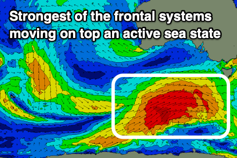
Moving into Friday and a larger S/SW groundswell is on the cards, generated by a stronger polar low developing on the polar shelf tomorrow south-east of the Heard Island region. A tight fetch of severe-gale W/NW winds are due to track east-northeast ideally through our southern swell window while broadening but slightly weakening. This frontal progression will move on top of the active sea state created before it, boosting the swell potential, with a large S/SW groundswell now on track for Friday afternoon.
Size wise, the morning should come in at 3-5ft, with the groundswell kicking to 6ft across Middleton and bigger across more exposed deep water breaks late afternoon. With the southerly direction the Mid isn't likely to top 1ft.
Winds will linger onshore from the S/SW, but if we're lucky we may see a dawn W'ly around Victor. We'll have a closer look at this Wednesday.
Come Saturday winds are due to swing back to the E/NE along with solid amounts of S/SW swell easing from 4-5ft+ early on the South Coast, smaller Sunday with similar E/NE to possible NE morning winds.
Beyond this burst of swell activity there's not much behind it, so try and work some of the days over the coming period, with plenty of size, but just some added bumps to deal with.

