A couple of good swells on the way
South Australian Forecast by Craig Brokensha (issued Monday 6th January)
Best Days: Keen surfers South Coast Wednesday morning, South Coast Thursday morning, early Friday exposed beaches South Coast, Mid Coast Saturday and Sunday
Recap
Poor surf across the South Coast all weekend, while Friday's change kicked up more size than expected on the Mid Coast Saturday morning, coming in at 2ft or so with cross-shore winds, a touch smaller and cleaner Sunday.
Today the surf was still poor and average on the South Coast with gusty E-E/SE winds, clean but tiny on the Mid Coast.
This week and weekend (Jan 7 – 12)
Tomorrow will be a lay day for the South Coast with the mix of swells today easing back in size along with a moderate SE-E/SE breeze, freshening from the S/SE through the day.
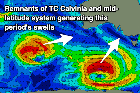
The Mid Coast will be tiny, but a new pulse of W/SW groundswell may be seen into the afternoon, generated by the remnants of Tropical Cyclone Calvinia.
 The remnants drifted in from the southern Indian Ocean over the weekend and has since deepened south of WA yesterday. An initial fetch of pre-frontal W/NW gales should generate a small spike in W/SW groundswell tomorrow afternoon, but a polar low forming yesterday has generated a fetch of W/SW gales in our south-western swell window.
The W/SW swell isn't expected to offer much over 1ft on the sets across the Mid Coast, while the SW groundswell for the South Coast should build Wednesday to 3ft to occasionally 4ft from Middleton to Goolwa.
The slow movement of the low will see the swell prolonged a little longer than usual, with Thursday due to ease back from 3ft+ across the Middleton stretch.
Now, winds on Wednesday will improve a touch, swinging E-E/SE ahead of sea breezes, but Thursday looks the pick with a fresh NE'ly ahead of SE sea breezes. An onshore change is due on Friday as the swell continues to ease but we may see a morning W/NW breeze favouring some locations.
This change will be linked to a strengthening frontal system being pushed east by a strong high and will generate a boost in short-range S'ly swell on the weekend across the South Coast but with poor and strong S/SE winds on Saturday and hopefully better E/NE winds Sunday morning as the swell eases.
The Mid Coast should see a fun and inconsistent W/SW swell in the mix, produced by a distant mid-latitude storm that's currently formed north-east of the Heard Island region. A great fetch of strong to gale-force W/SW winds are being projected through our western swell window, with the storm due to weaken south-west of WA Wednesday.
The swell is due to fill in Saturday and provide good 2ft sets on the Mid Coast with the help of the favourable parts of the tide, easing from 1ft to possibly 2ft Sunday. Longer term it looks like we'll see S'ly winds and average swells next week, so make the most of the coming waves.

