Poor weekend, better surf next week
South Australian Forecast by Craig Brokensha (issued Friday 27th December)
Best Days: South Coast Monday, keen surfers Mid Coast, Mid Coast Tuesday and Wednesday mornings, Friday morning South Coast
Recap
Poor surf yesterday with a flat Mid Coast and small onshore windswell across the South Coast. A late pulse of new W/SW groundswell did show on dark with sets to 1ft+, but the peak has been seen today with inconsistent but good and clean 2ft waves on the Mid Coast beaches and reefs.
The South Coast is also offering a bit more size but conditions aren't the best with an easterly breeze. We'll see the swell hold all day but with afternoon sea breezes.


This weekend and next week (Dec 28 – Jan 2)
Today's inconsistent W/SW groundswell has peaked on the Cape du Couedic wave buoy and we'll see it easing off this evening, further into the weekend.
Unfortunately winds are looking average across all locations tomorrow besides from dawn. Early variable and offshore winds are expected across both the Mid and South Coasts with a drop in swell back to 1-1.5ft and 2ft respectively. Onshore SW winds will move in soon after though, so it's not worth chasing a wave too far.
 Sunday will see the swell bottom out with a S/SE-SE breeze.. a lay day.
Moving into next week, and our increase in swell activity from the W/SW is still on track, with a flurry of strong mid-latitude frontal systems due to produce plenty of surf from Monday through Friday.
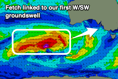
The first and strongest but most distant of these storms has developed west-southwest of WA, with a fetch of gale to severe-gale W/SW winds being generated in our western swell window.
This front is stronger and will push further east than the system linked to today's swell, hence generating a stronger, larger and more consistent W/SW groundswell that's expected to fill in Monday and peak through the afternoon.
We're looking at good 2-3ft sets into the afternoon with the help of the slight tidal push, while Middleton should kick to 3ft+ from Day St onwards.
Winds are an issue with this swell though as another weaker but broader mid-latitude storm moves in from the west, bringing fresh N/NE tending stronger N/NW winds late morning and then a strong early evening SW change.
A secondary pulse of moderate sized W/SW groundswell is due off this front into Tuesday, though more mid-period in energy.
We should see the Mid Coast persisting around 2-3ft, easing from this size on Wednesday morning, with the South Coast kicking later in the day to 3-4ft off Middleton, holding Wednesday morning and easing later.
Winds will be an issue though with fresh S/SW breezes due across both coasts Tuesday though more than likely S/SE early on the Mid Coast. Wednesday looks similar though with winds being only moderate in strength and conditions cleaner on the Mid Coast.
The swell will ease into the end of the week while tending more SW in direction, though winds don't look to full improve across the South Coast until Friday, swinging NE with a small easing swell from 2ft or so off Middleton. More on this Monday. Have a great weekend!


Comments
winds will be a problem
winds will be a problem
winds will be a problem
F*%k I HATE summer.
Just have to think outside the square a little.. Or drop those expectations and just be happy to connect a few turns together.
Learn how to kite and you’ll get a froth on either way. Wind and waves is just as good as waves with a kite yahabo.
In yorkes on Sunday and Monday should I pull the pin now or do you think the winds and swell will play ball Monday morning?
Can't give too much away but I wouldn't dawdle Monday morning.
The swell is still looking good.
Smoking on the Mid... no seabreeze... almost 37 degrees... this swell was forecast over a week ago... and it's Xmas holidays with just a couple in the water. Where is everyone?

New swell is building pretty quickly down south. Was tiny at dawn!


West of Victor had some good sets. Straighthanders almost everywhere though.