Small swells, larger into the weekend but from the south

South Australian Forecast by Craig Brokensha (issued Monday 16th December)
Best Days: South Coast swell magnets tomorrow morning, Mid Coast Thursday and South Coast swell magnets Thursday morning, Mid Coast dawn Friday, South Coast swell magnets Friday morning
Recap
Small and bumpy waves on the South Coast Saturday, tiny and clean on the Mid Coast.
Sunday saw cleaner conditions with a light offshore wind, but only small surf, best at the swell magnets.
Today a better inconsistent new W/SW groundswell has filled in, providing 1ft+ sets on the Mid Coast, 2-3ft sets along the Middleton to Goolwa stretch with light offshore winds across both locations.
This week and weekend (Dec 17 - 22)
This morning's peak in inconsistent groundswell will ease off slowly over the coming days, bottoming out on Wednesday.
Winds will shift NE tomorrow morning, creating clean conditions again and favouring the more exposed breaks with small easing sets from 2ft between Middleton and Goolwa, better at Waits and Parsons for more size and power. The Mid Coast is due to drop back from 0.5ft or so.
Wednesday will be hot and clean with a N/NE offshore but the swell on the tiny side down South with small runners maybe to 2ft at Waits and Parsons, easing through the day.
Our new inconsistent W/SW swells for Thursday and Friday are still on track, with a couple of strong back to back mid-latitude storms firing up west-southwest of WA over the weekend. These swells will favour the Mid Coast over the South Coast with inconsistent 1-2ft sets due on the gulf swell magnets on the favourable parts of the tide, with 2ft waves from late morning at Day St/Goolwa.
A secondary pulse of swell is due Friday to a similar size and looking at the local winds, both locations should be clean Thursday morning with an E/NE breeze, giving into S/SE sea breezes and then best down South Friday with a freshening and hot N/NE tending stronger N/NW breeze ahead of a late cool SW change.
This change will then leave S/SE winds into Saturday with a poor windswell on the South Coast and tiny leftovers on the Mid.
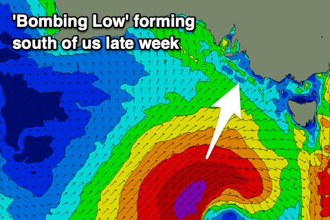 Looking to our south-west, a significant storm is forecast to develop in the Southern Ocean, in fact it'll be a 'bombing low' with a couple of low pressure centres west-southwest of WA expected to track south-east, with one of them dropping over 24hPa in central pressure in less than 24 hours.
The low will drop to 961hPa south-southwest of Tassie, with a fetch of severe-gale to storm-force S/SW winds forming on its backside, moving slowly east through our southern swell window Friday and Saturday. The movement will be that slow that it'll only leave our swell window come Sunday morning.
A large, long-period S/SW tending S'ly groundswell is due from this low, with the biggest and best pulse due Sunday, with exposed breaks on the South Coast due to come in at 6ft, with a good chance for bigger cleanups in the mix, while the Mid Coast is due to see a tiny W/SW swell in the mix to 1-1.5ft.
Strong SE tending S/SE winds will create generally poor conditions, with the swell easing slowly Monday but with unfavourable morning E/SE winds persisting.
Tuesday morning should become slowly cleaner but the swell back to 3ft or so. More on this swell and the local winds Wednesday.