Good swell and winds for the coming days
South Australian Forecast by Craig Brokensha (issued Friday 22nd November)
Best Days: Both coasts tomorrow and Sunday, early Monday on the MId, South Coast Monday morning
Recap
A dawn window of clean conditions down South yesterday before a cold onshore change hit, along with building levels of windswell on the Mid Coast.
Today has remained small and onshore down South, cleaner on the Mid with novelty 1ft+ waves. There's a bit more definition to the swell now with the odd 1.5ft set on the Mid Coast swell magnets.

This weekend and next week (Nov 23 - 29)
After a couple of average days of waves, we look towards the swell over the weekend.
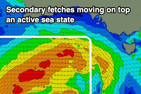
The initial strongest stages of the frontal progression linked to this swell has already taken place, south-west of WA with a good fetch of W/SW gales produced through our western swell window.
 We're now seeing the secondary stages of the progression, with a broad and strong fetch of W/SW winds pushing over the top of the active sea state, south of WA and slowly towards us today, and this evening, slipping slowly east-southeast through tomorrow.
A mix of W/SW groundswell and mid-period SW swell should build through tomorrow, reaching 2ft+ through the afternoon on the Mid Coast with the help of a small incoming tide, 3-4ft off Middleton.
Sunday should see surf holding around 2ft+ on the favourable parts of the tide on the Mid Coast, with a bit more consistent and more solid surf to 4ft off Middleton.
Local winds are still looking good with a variable tending light E/SE breeze tomorrow morning on the Mid, with workable sea breezes, with W/NW tending SW and then S/SW winds down South.
A light to moderate N/NE offshore is expected down South Sunday morning ahead of sea breezes, E/NE on the Mid ahead of sea breezes.
Winds will take a little more northerly bias across the Mid Coast on Monday morning adding some bumps with easing 1-2ft sets on the favourable parts of the tide, NE-N/NE down South with easing 3ft+ sets off Middleton. Winds will quickly swing onshore across both coasts late morning with a trough moving through so don't dawdle.
A lift in mid-period and windswelly SW swell is expected in the wake of this trough/front on Tuesday but with onshore S/SW winds across both coasts. The Mid Coast looks to persist around 1-2ft, with a kick in size to 3ft on the South Coast.
Winds look to linger onshore Wednesday as the size eases, mixed in with a small, distant SW groundswell.
Longer term we may see a slow moving and broad but relatively weak polar low forming south of us is likely to generate a good S/SW swell late week and into the weekend, but the winds may go south. More on this Monday. Have a great weekend!


Comments
Today's new W/SW swell..
Nice waves on this Mid this morning.


Looking nice down south too!


It's been a while for Middleton to have good swell and offshore winds. Well done swellnet!! Had great waves this morning.
Stoked! The Mid looked great as well all weekend!