Good run of W/SW swell on the way
South Australian Surf Forecast by Craig Brokensha (issued Friday 31st August)
Best Days: Saturday morning South Coast, keen surfers on the Mid, Monday, Tuesday, Wednesday across both coasts
Recap
OK but not great conditions on the South Coast yesterday with plenty of swell and winds out of the E/NE through the morning, much better today with sets hanging in at 3ft off Middleton with N/NE offshores. A new S/SW groundswell is due this afternoon and this should kick wave heights up to 3-4ft off Middleton as winds hold.
The Mid Coast saw a sneaky pulse of W/SW groundswell to 1-1.5ft with great conditions all day, tiny this morning.
Today’s Forecaster Notes are brought to you by Rip Curl
This weekend and next week (Sep 1 – 6)
Today’s S/SW groundswell will drop back through the weekend, but a new couple of new W/SW groundswells will provide a kick in size on the Mid Coast tomorrow and later Sunday through Monday.
Easing 2-3ft sets are due off Middleton tomorrow morning, small into the afternoon with great fresh N/NE tending N/NW winds. The Mid Coast should see inconsistent 2ft sets on the favourable parts of the tide, generated by a tight and intense low that was positioned south-west of WA earlier this week. It’ll be wind affected though and only for the keen.
 A secondary slower moving and broader fetch of W/SW winds behind this low has generate a better W/SW groundswell for later Sunday and more so Monday, kicking back to 1-2ft later and peaking Monday to 2ft+, with the odd 3ft set possibly on the magnets working the tides.
In between this on Sunday morning the surf looks small to tiny with early gusty N/NW winds, shifting W/NW through the morning ahead of a W/SW change.
Monday still looks favourable for both coasts with a fresh morning NE breeze on the Mid, N/NW into the afternoon and fresh N/NE tending NW winds down South. Middleton won’t offer too much size with the westerly swell direction coming in small around the Point and to 2ft, better to 3ft towards Goolwa.
Tuesday looks fun across both coasts again with a reinforcing mid-period W/SW swell to 2ft on the Mid Coast with light morning E/NE winds, N/NW down South with a slight drop in size to 2ft along the Middleton stretch.
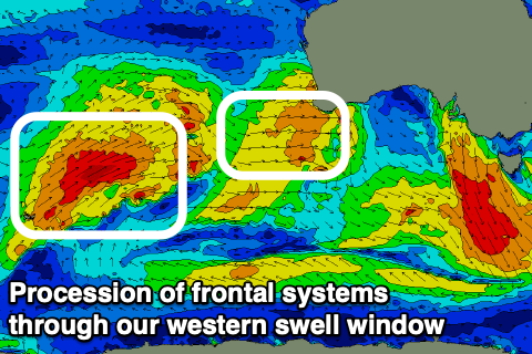
Moving into the middle to end of the week, we’ll see a flurry of strong mid-latitude frontal systems pushing up and across WA, weakening while dipping east-southeast towards us. As some of these fronts move under WA, great fetches of W/SW gales will be generated through our western swell, window, producing a good moderate sized W/SW groundswell for Wednesday.
The Mid Coast should build to 2-3ft through the day, with Middleton increasing to an inconsistent 2-3ft with favourable NE tending NW winds.
We may see a SW change on Thursday as the swell eases, but more on this Monday. Have a great weekend!

