Great Friday, smaller mixed weekend
South Australian Forecast by Craig Brokensha (issued Wednesday 21st August)
Best Days: Mid Coast early tomorrow and Friday morning keen surfers, South Coast Friday and Saturday exposed beaches, Mid Coast Sunday (though inconsistent)
Recap
OK waves in protected spots yesterday on the South Coast with 3-5ft surf in the morning, easing through the day, while the Mid Coast was a bumpy 2ft, with 3ft'ers on the favourable parts of the tide.
Today a new pulse of SW swell is filling in with 4-5ft surf off Middleton, though bumpy again, 2ft on the Mid Coast with onshore winds. Winds will shift more onshore across the South Coast through the morning as the swell continues to kick.
Today’s Forecaster Notes are brought to you by Rip Curl
This week and weekend (Aug 22 - 25)
A strong cold front is currently pushing across the south-east corner of the country and this has generated large pulse of new SW groundswell today.
This swell is due to peak this afternoon across the state, but tomorrow morning will remain large as a secondary small embedded front projects a fetch of SW gales up and into Victoria, on the edge of our swell window.
4-5ft waves should be seen off Middleton tomorrow morning, 1-2ft on the Mid Coast on the favourable parts of the tide, easing later and dropping further from 3-4ft Friday morning. An inconsistent and long-range W/SW groundswell will be in the mix, but not to the size of the local S/SW swell, and the models are over-forecasting this and incorrectly combining the different swells.
Conditions will be average tomorrow as winds swing SW-S/SW in the wake of the front pushing towards Victoria, likely SE early on the Mid creating cleaner conditions.
Friday looks excellent though down South with a moderate to fresh N/NE tending N/NW breeze. The Mid Coast will be OK early but on the small to tiny side and 1ft to occasionally 2ft on the favourable parts of the tide.
 Saturday morning will be clean again down South with a N/NW offshore wind and smaller easing surf from 2ft+ off Middleton. A small reinforcing swell may steady wave heights through the day, and a trough moving through will bring a late onshore change.
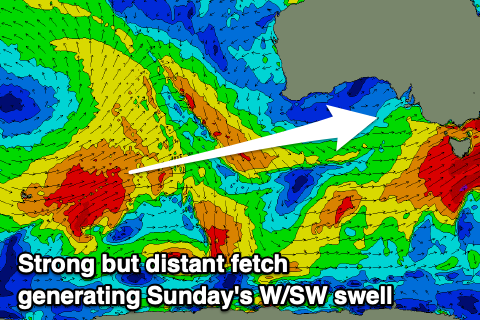
Now, the models are slowly converging regarding this incoming front/trough and as expected GFS has trended towards EC which will see no real significant swell into Sunday as a weaker surface trough moves in from the west, aiming a fetch of strong SW winds through our swell window.
The earlier stages of this front saw a distant fetch of W/SW gales generated in our swell window, producing an inconsistent W/SW groundswell for the Mid Coast as well.
Winds will linger onshore from the S'th in the wake of the trough Sunday as the new swells build, possibly better Monday with more variable winds, though we'll look at this again Friday. The Mid Coast should see inconsistent 1-2ft sets into the afternoon, with building surf to 3-4ft off Middleton, easing from a similar size Monday.
Longer term there's a fun mix of long-range and medium-range swells for Wednesday as winds tend back to the north-east but more on this Friday.


Comments
CDC wave buoy is back and with new direction observations and those error bars might be directional spread? Will have to keep eye on.