Up and down over the coming days, larger and windier next week
South Australian Forecast by Craig Brokensha (issued Wednesday 31st July)
Best Days: Mid Coast late tomorrow and Friday morning, South Coast Friday and Saturday mornings, Sunday, Monday morning swell magnets
Recap
Light offshore winds and improving lumpy waves off the South Coast yesterday, good into the afternoon, while this morning was cleaner and straighter as 3ft sets continued off Middleton.
The Mid Coast has hovered between 0.5-1ft both yesterday and today.
Today’s Forecaster Notes are brought to you by Rip Curl
This week and weekend (Aug 1 - 4)
Tomorrow looks to be a lay day with the swell becoming small down South along with a weak surface trough moving through at dawn, bringing onshore winds. Hi-res modelling is showing winds may stay favourable around Middleton/Goolwa if you're in the area and up for a surf.
Later in the day a new W/SW groundswell should be seen, peaking Friday mixed in with a couple of smaller SW swell signals.
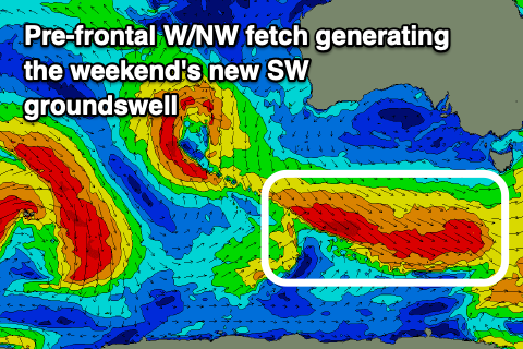
These swells are being generated by the one system, with the W/SW energy produced by a pre-frontal fetch of severe-gale W/NW winds south of WA yesterday. The post-frontal fetch linked to the SW swell looks weaker now and not as favourable, while a very tight and intense low spawning off this post-frontal fetch will produce a burst of severe-gale W/SW winds briefly in our southern swell window early tomorrow morning.
We should see the W/SW groundswell kicking later tomorrow on the Mid Coast and reaching 1ft to maybe 2ft with the incoming tide, peaking around the same size Friday. Middleton should kick to 2-3ft later tomorrow and peak Friday to 3ft+.
Winds should be favourable for both coasts Friday morning, variable on the Mid and W/NW on the South Coast before shifting onshore across both regions into the afternoon.
The swell will ease Saturday from 3ft on the sets off Middleton, tiny on the Mid Coast and with similar winds to Friday, variable on the Mid in the morning and W/NW across the South Coast through the morning.
 A new S/SW groundswell is expected Sunday morning on the South Coast, though not to the size shown by our models. A broad and elongated fetch of pre-frontal W/NW gales forming just within our southern swell window should produce the swell on Friday, with it arriving Saturday evening and then easing Sunday from 3ft on the sets across Middleton as the Mid Coast remains tiny.
Conditions will be great with a persistent moderate to fresh N/NW'ly blowing all day.
Monday will see good but fresher N/NW tending W/NW winds though with a small fading swell from 1-2ft off Middleton.
Of greater importance are the developments into mid-late next week, with a strong mid-latitude frontal progression due to push in and strengthen on approach. This will generating larger windier swells mid-late next week, best suited to protected spots down South, but more on this Friday.

