Good windows of waves across both coasts this period
South Australian Forecast by Craig Brokensha (issued Wednesday 24th July)
Best Days: South Coast tomorrow and Mid Coast early, Mid Coast Friday, South Coast Saturday and Sunday morning, Mid Coast for the keen Sunday, early Monday South Coast
Recap
Solid 3-4ft of W/SW groundswell with NW winds yesterday on the Mid, creating generally average conditions, cleaning up into this morning and still to a good 3ft+ along with a lighter N/NW breeze.
The South Coast built in size yesterday with winds increasing and being best for more protected spots, cleaner with a drop in size through today, though still solid and only for the experienced.
Today’s Forecaster Notes are brought to you by Rip Curl
This week and weekend (Jul 16 – 21)
The coming days will be really fun on the South Coast (bar Friday) with the swell easing back further into tomorrow to 3ft to occasionally 4ft off Middleton and 2ft sets on the Mid Coast. A new W/SW groundswell is due into the late afternoon, holding all day Friday to a similar size.
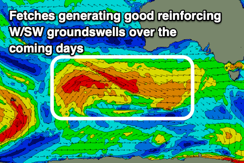
 This has and is still being generated by a mid-latitude front passing under WA, with a fetch of W/NW gales projected through our western swell window.
Conditions tomorrow will be great all day down South with a moderate to fresh N/NW breeze, while the Mid Coast will see an early N/NE breeze creating decent conditions.
A trough moving through on Friday will bring a gusty S/SE change right on dawn, turning our attention to the Mid Coast which should continue to see 2ft sets on the favourable parts of the tide.
Another cold front moving in from the west will see winds go back to the N'th on Saturday morning (NE early on the Mid) and then W/NW into the afternoon as the swell eases back a touch. A new SW groundswell is then due Sunday morning ahead of a slightly bigger pulse later in the day, but more so Monday.
These swells will be produced by a slimmer and more distant fetch of pre-frontal W/NW gales under WA late week, followed by a small but strengthening post-frontal W/SW fetch moving under us on the weekend.
Size wise Middleton looks to offer 3ft+ waves Sunday, with the odd 4ft set late in the day and more so Monday morning, and then 1-1.5ft on the Mid Coast, with odd 2ft sets on the favourable parts of the tide, but mostly just shy of this.
Winds on Sunday will be favourable for both coasts, but not perfect down South and out of the NE-E/NE, ahead of weak sea breezes, and then W-W/SW on Monday, best in protected spots down South early.
This change will be linked to another trough and then high moving through, bringing poor S/SE winds on Tuesday with a new long-range swell, but not much in the way of size for the Mid Coast. Better waves are due into the end of the week with a better long-range swell and winds out of the north-east. More on this Friday though.

