Large swells and winds inbound
South Australian Forecast by Craig Brokensha (issued Friday 12th July)
Best Days: Protected spots South Coast Sunday morning, Tuesday morning, Wednesday, Thursday and Friday
Recap
Stormy waves between 3-4ft on the Mid Coast yesterday and today, with Middleton a similar size though bumpy with a strong W/NW breeze. Still it's been fun on the right parts of the tide in protected spots for experienced surfers.
Today’s Forecaster Notes are brought to you by Rip Curl
This weekend and next week (Jul 13 – 19)
We're currently seeing the strongest of the frontal systems in this week's progression of storms pushing up and towards the Adelaide region.
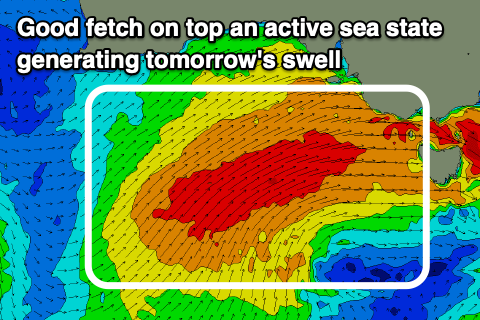
 Last night a fetch of gale to near severe-gale W/SW winds were generated south of the Bight, in our south-western swell window, and now the front is heading towards us in a weakened form, pushing into the south-east later this afternoon/evening.
The largest waves of the past few days will be seen tomorrow on the South Coast with Middleton coming in at 6ft to occasionally 8ft but with poor and strong SW winds, easing through the day. There's a very slim chance for an early W'ly around Victor, but I wouldn't count on it. The Mid Coast will be semi-stormy and easing from 3ft+.
Sunday morning looks much cleaner on the South Coast as the secondary front approaching from the south-west swings winds back to the W/NW along with a drop in swell back to the 4-5ft range off Middleton, W/SW from late morning.
The Mid Coast will remain bumpy and onshore with waves back to 2ft+ on the favourable parts of the tide. Late in the day and more so Monday a new S/SW groundswell should start building across the South Coast, generated by a strong polar low that's formed south-west of WA.
A fetch of severe-gale to storm-force W/SW winds are currently being generated in our swell window, but the low will race a little too quickly to the east and the push up and into Victoria Sunday as a weaker front, escaping the swell it's generating.
 This will limit the expected size, with a downgrade from Wednesday when it was expected to be slower moving.
We'll still see large waves on the South Coast, possibly kicking late Sunday but filling in Monday with the size, building to 6-8ft across most exposed breaks during the day, likely undersized early. The direction isn't ideal for the Mid Coast and easing surf back to 1ft to possibly 2ft on the favourable parts of the tide expected.
Conditions won't improve unfortunately with onshore S/SW tending SW winds across both regions, better Tuesday down South as the swell eases with an early W/NW breeze likely. Wednesday is looking best with a fresh and strengthening W/NW breeze and easing waves from 3ft off Middleton.
For the rest of the week, small and fun mid-period SW swells are due to keep the South Coast active, with small to tiny onshore waves on the Mid under persistent north-west winds. We may see a good new swell next weekend, but more on this Monday. Have a great weekend!

