Lots of swells mostly out of the west and mostly windy
South Australian Forecast by Craig Brokensha (issued Monday 10th June)
Best Days: South Coast tomorrow and protected spots down South Wednesday, Thursday, Friday and Saturday, Mid Coast Friday and Sunday
Recap
Tiny clean waves all weekend down South and into this morning with no decent swell and persistent offshore winds.
The Mid Coast was also tiny, while today a new acute W'ly (even W/NW swell) has filled in with average N/NW winds. The size is a little under expectations owing to winds through the gulf and the Bight being more NW than W.
Today’s Forecaster Notes are brought to you by Rip Curl
This week and weekend (Jun 11 - 16)
Due to the direction of today's W/NW-W swell, the South Coast has remained tiny, but tomorrow we should see a slightly better aligned W/SW groundswell filling in.
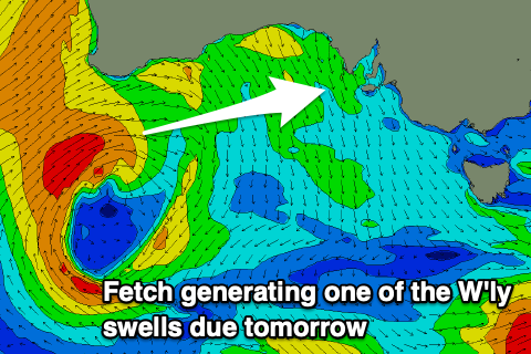
 There'll be two components of this swell. The most reliable will be very W in nature, generated by a fetch of gale-force W/SW winds south-west and south of WA over the weekend, and this should produce 2-3ft of groundswell for the Mid Coast, with 2-3ft waves off Middleton, but a less reliable but better alined (for the South Coast) W/SW groundswell was also generated by the earlier stages of this storm.
A fetch of severe-gale S/SW winds were projected up towards WA, just within our swell window with fun levels of W/SW swell spreading out radially from this source. Hopefully we'll see this push Middleton more to the consistent 3ft range tomorrow, though from about Day St further east.
Winds tomorrow will be great for the South Coast all day with a persistent N-N/NE offshore wind, while the Mid Coast will remain bumpy and not ideal.
A W/NW breeze will then be seen on Wednesday as the W/SW swells ease from 2ft off Middleton on the sets and the Mid Coast persists at 2ft.
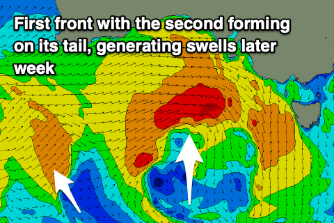
Later in the day we may see a new W/SW swell building across both coasts but Thursday is a much better chance for this, with an additional swell showing late in the day and peaking Friday morning.
These swells will be generated by back to back mid-latitude storms pushing in from the west, with the first producing a fetch of strong W/SW-W winds moving through the Bight, with a small core of gale-force W'ly winds.
The Mid Coast should kick back to 2-3ft on Thursday, with Middleton coming in at a similar 3ft, while a secondary fetch of W/SW gales pushing in closely behind will kick wave heights a little further late in the day, peaking Friday to a better 4ft off Middleton as the Mid Coast persists at 2-3ft.
 Winds on Thursday will persist out of the W/NW, favouring protected spots down South, while Friday looks similar though with weaker W/NW-W winds creating more workable conditions on the Mid Coast.
Both swells are due to ease into Saturday with a NW tending W/NW breeze, and background swell energy won't see Middleton drop below 2-3ft on Sunday.
It looks like we'll see a S/SE change on Sunday though after early variable winds as a surface trough moves in from the west. This will clean up the Mid Coast but it looks like we'll be back to a small 1-2ft with the arrival of a small new W/SW swell.
Longer term some broader and more sustained polar frontal activity south-west of WA and then under the country on the weekend should produce some better SW groundswell through early-mid next week though winds may become stronger from the S'th as a low forms over Victoria. More on this Wednesday.

