Tiny weekend ahead of persistent windy westerly swells next week
South Australian Forecast by Craig Brokensha (issued Friday 7th June)
Best Days: South Coast Tuesday and Wednesday morning, Mid Coast Tuesday afternoon, South Coast Thursday morning
Recap
Light winds and cleaner though lumpy conditions yesterday with a small pulse of swell to 2ft off Middleton. Today is much better with clean and straight small 2ft waves off Middleton with a little more size at Waits and Parsons,
The Mid Coast provided an unexpected pulse of W/SW swell yesterday to 1-1.5ft, more than likely the same W/SW swell that hit Margs for finals day, with it dropping back in size today.
Today’s Forecaster Notes are brought to you by Rip Curl
This weekend and week (Jun 8 - 14)
Make the most of this afternoon's waves because as we move into the weekend, the outlook is very dire with no new swell with size expected as offshore winds persist.
Today's groundswell will ease tomorrow leaving 1ft sets off Middleton and maybe the odd 1-2ft wave at Waits and Parsons, tiny into the afternoon with a persistent moderate to fresh N tending N/NW breeze.
Sunday will be a lay day with fresh and persistent N'ly winds.
 Moving into next week we'll see windy and very acute W'ly swells across the Mid Coast, being quite stormy in nature while the South Coast will be small to tiny, best on Tuesday.
A flurry of mid-latitude storms moving up and into Western Australia will then track east, dropping from over land into the Bight on Sunday and then across us Monday.
We'll see a tricky but strong burst of W'ly gales through our western swell window Sunday, shifting NW and out of our swell window through Monday.
What we'll see is an increase in acute W-W/NW swell on Monday followed by a slightly better aligned W/SW groundswell signal on Tuesday, favouring the South Coast.
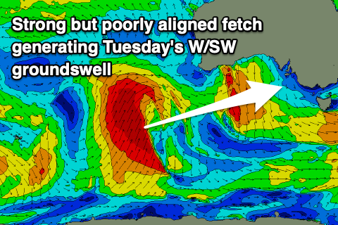
 The groundswell will be generated today and tomorrow by the earlier stages of one of these mid-latitude storms, forming south-west of Western Australia and projecting up towards that state while producing a fetch of gale to severe-gale S/SW winds. This fetch will be poorly aligned, along with its track, but we should still see moderate levels of W/SW groundswell for Tuesday.
Coming back to Monday and the South Coast looks to remain tiny with the Mid Coast coming in around a stormy 3ft or so out of the W/NW. Strong W/NW-NW winds are due to ease and tend more NW through the afternoon but with no size down South, it'll all go to waste.
The W/SW groundswell on Tuesday should produce 3ft sets off Middleton, while the Mid Coast looks to persist at 3ft. Winds will improve for all locations with a N/NW tending N'ly breeze, creating OK waves on the Mid Coast later in the day.
The swells will ease into Wednesday and another strong front approaching from the west will bring a stormy building W/SW swell that will build even further into the end of the week as back to back storms move through the Bight.
The South Coast will be limited in size with the westerly direction but clean in protected spots, while a larger SW groundswell may be seen into next weekend. More on this Monday though. Have a great weekend!

