Small to tiny swells for the period as winds improve
South Australian Forecast by Craig Brokensha (issued Monday 3rd June)
Best Days: No great days, but try the South Coast swell magnets Friday
Recap
Saturday finally provided a light offshore wind and fun easing 2-3ft surf across Middleton on the South Coast, great on the magnets, with Sunday also clean but tiny.
The Mid Coast was tiny all weekend, clean Saturday and onshore Sunday.
Today a deepening low moving up from the south-west has brought strong onshore winds and a stormy increase in swell on the South Coast, tiny and choppy on the Mid.
Today’s Forecaster Notes are brought to you by Rip Curl
This week and weekend (Jun 4 - 9)
The coming week isn't looking that special at all surf wise, we'll see onshore and fresh S/SE winds persisting tomorrow along with a drop in S'ly windswell from 3ft or so off Middleton, tiny and peaky on the Mid Coast.
 Winds should swing become more variable and tend E/NE-NE on Wednesday morning creating improving conditions on the South Coast but there'll hardly be any size or power left to the swell with easing 1-1.5ft sets off Middleton, maybe 2ft off Waits and Parsons. Either way if you're planning a surf, keep your expectations low.
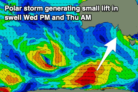
A small pulse of long-period S/SW groundswell is due on Wednesday afternoon and Thursday morning from a poorly aligned and short-lived polar fetch of W'ly gales south of WA this morning.
No major size is expected off this front, with 1-2ft sets due off Middleton Wednesday afternoon (with sea breezes) and Thursday morning, coming in at a better 2ft+ at Waits and Parsons.
Winds on Thursday look dicey as well with a light to moderate SW'ly possibly tending variable for a period, but we'll review this on Wednesday.
Friday will be cleaner with a N/NE offshore though with no real change in size, with a background swell due to keep Middleton ticking along at a tiny 1-1.5ft, best at Waits and Parsons.
Into the weekend we'll see persistent N'ly offshore winds but tiny surf down South and nothing on the Mid Coast.
A blocking pattern will continue to deflect storms south away from our swell windows until early next week. This is when we should see a lot more activity through the Southern Ocean, south of the country as a strong node of the Long Wave Trough moves in from the west. More on this Wednesday though.


Comments
:(