Good waves continue for the South Coast, with a fun Mid Coast swell
South Australian Forecast by Craig Brokensha (issued Wednesday 15th May)
Best Days: South Coast magnets tomorrow, South Coast Friday, Mid Coast Saturday afternoon and Sunday morning, South Coast all weekend
Recap
Pumping waves on the South Coast the last two days with 3-4ft of SW groundswell yesterday and persistent offshore winds, easing back to 3ft today as winds remained favourable. The Mid Coast saw infrequent 1-2ft waves yesterday morning, though dropped back to 1-1.5ft through the day, persisting at a clean 1-1.5ft today.
Today’s Forecaster Notes are brought to you by Rip Curl
This week and weekend (May 16 – 19)
The surf will continue to ease back through tomorrow from a small 2ft off Middleton, best at Waits and Parsons with a N/NE offshore, variable into the afternoon. The Mid Coast will be tiny and slightly wind affected.
Our new long-period and inconsistent SW groundswell for Friday morning is still on track, with it generated early this week east of Heard Island by an intense polar low.
 Infrequent surf to 3-4ft is expected off Middleton, with the Mid Coast remaining tiny due to the origins of the swell being south.
Conditions will remain great with a moderate to fresh N/NE tending variable breeze again on the South Coast.
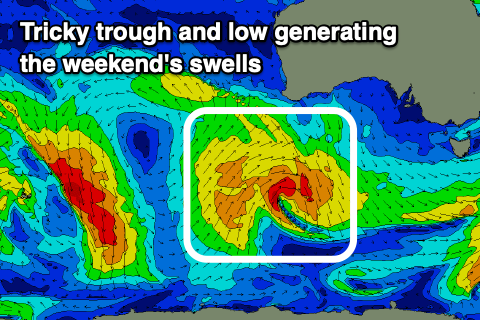
Into the weekend our tricky pulses of W/SW and SW swell are still on track as a surface trough moves in from the south-west of WA today. A fetch of strong W/SW-SW winds will be projected through our western swell window, while a tight low forming further south will produce a poorly aligned fetch of S/SW gales in our south-western and southern swell window.
The W/SW swell should fill in on Saturday and kick the Mid Coast to 2ft+ through the day, while the South Coast is expected to build to 3ft through the day. At this stage it looks like our models are incorrectly combining a mix of swells, and I wouldn't expect much in the way of size Saturday morning.
Winds will remain favourable for both coasts as the remnants of the trough forms a stalling low to our west, directing N/NE tending E/NE winds across the region.
The swells look to ease back into Sunday from 2ft on the Mid Coast and 3ft off Middleton and winds will remain favourable though fresher from the N/NE in the morning, shifting N/NW into the afternoon.
The low is now expected to lose most of its steam while sitting in the Bight with our stormy swell for Sunday and Monday for the Mid Coast not on the cards anymore, let alone any meaningful increase in size at all.
We'll see the surf continuing to ease early next week on the Mid Coast, while a strong polar storm firing up late in our swell window looks to generate a new S/SW groundswell, for Monday, possibly followed by a secondary increase Tuesday.
Size wise we may see 3ft surf off Middleton, tiny on the Mid Coast, though a W/SW change will spoil conditions Monday, cleaner Tuesday. More on this tricky period Friday.


Comments
How are we looking for Pondie tomorrow?
Well swell direction and winds aren't great for it..
Doh! Thanks for the reply though.
Any suggestions for yorkes tomorrow?
Can't give too much away. There'll be swell and winds will be good for a few places, check out Google Maps.