Plenty of swell this week, though winds aren't too flash

South Australian Forecast by Craig Brokensha (issued Monday 18th February)
Best Days: Mid Coast tomorrow morning, South Coast Wednesday morning, South Coast Friday, Saturday and Sunday mornings
Recap
Average sloppy waves down South on Saturday but fun and clean yesterday morning with offshore winds holding most of the day. The Mid Coast was clean but tiny Saturday, flat yesterday.
This morning all locations are poor with a low point in swell and onshore winds down South. Keep an eye on the Mid Coast as we may see a tiny pulse in swell this afternoon to 1ft+.
Today’s Forecaster Notes are brought to you by Rip Curl
This week and weekend (Feb 19 - 24)
Our good pulse of new SW groundswell for tomorrow is still on track, but unfortunately so are the onshore winds.
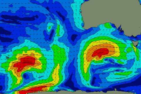 Over the past couple of days a strong and slow moving low has been projecting a fetch of W/SW-SW gales towards us (right), producing a strong consistent swell which should peak tomorrow morning.
Middleton is expected to see 4-5ft sets, with 1-2ft waves on the Mid Coast on the favourable parts of the tide, but a moderate to fresh S/SW breeze will create average conditions down South, S/SE early on the Mid.
Wednesday is still looking dicey down South as the swell eases with a lighter W/SW breeze, that looks to tend light W/NW around Victor for a period with easing 3-4ft sets off Middleton. The Mid Coast should see an early S/SE breeze but will be tiny and easing from 1ft to possibly 1.5ft.
Make the most of Wednesday’s lighter winds down South though as S/SE winds kick back in and the swell drops into Thursday morning.
A new mid-period SW swell should start building Thursday afternoon, generated by a relatively weak mid-latitude front pushing in from the south-east Indian Ocean.
This was actually associated with a stronger distant storm over the weekend, producing very inconsistent long-period energy for Friday afternoon, but coming back to Thursday and Middleton should build back to 3ft, with 1ft sets on the Mid, ahead of a peak Friday to an infrequent 3ft+ down South, maintaining 1ft on the Mid.
Conditions will improve down South Friday as winds tend E/NE-NE, good again Saturday as the swell eases from 2-3ft off Middleton with a NE offshore. Sunday looks even straighter with a N/NE offshore, but the swell will be on the small side and easing.
Longer term there’s nothing significant on the cards for early next week as a strong blocking high moves in from the west, but this could easily change as the models diverge on the movements of Tropical Cyclone Oma in the Coral Sea, so check back here Wednesday for more on this.