Strong W/SW swell for the weekend with an improvement in winds

South Australian Forecast by Craig Brokensha (issued Friday 4th January)
Best Days: Both coasts tomorrow (protected spots South Coast during the morning), both coasts Sunday morning, possibly early Wednesday South Coast protected spots
Recap
Inconsistent though fun 1-2ft sets on the Mid Coast magnets early yesterday, dropping in size with the dropping tide. The South Coast was a little wobbly and morning sick early but cleaned up through the day with good 3-4ft sets off Middleton, bets towards Goolwa with a NE breeze.
Afternoon sea breezes kicked in creating bumpy conditions but then glassed off late providing a little window of good conditions ahead of today's small bumpy and onshore conditions.
Today’s Forecaster Notes are brought to you by Rip Curl
This weekend (Jan 5 - 11)
Currently a strong and powerful mid-latitude is tracking east-southeast under the Bight, with it having generated a tight gale to severe-gale W/SW fetch directly south-west of WA, with a couple of storm-force barbs recorded by satellite.
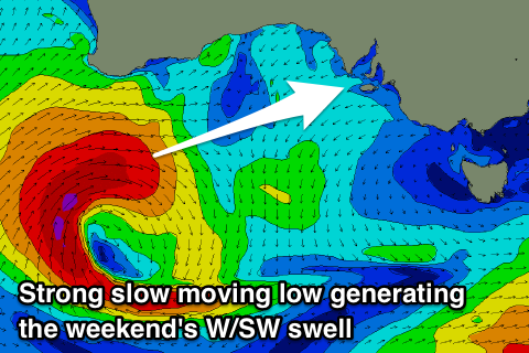 The low has since weakened slightly though was still generating a fetch fetch of W/SW gales through our western swell window, with it now moving more through our south-western swell window as it continues east towards Tassie.
A large long-period W/SW groundswell will be seen off this low, filing in tomorrow and peaking through the day to a strong 3ft on the Mid Coast with the South Coast building through the day and reaching an easy 4ft off Middleton, if not for the odd bigger one. The morning will be much smaller and starting from 2ft to possibly 3ft.
Now, winds aren't great for the Mid but have improved and will be helped by the strength of the swell there'll be fun waves. A moderate SW'ly is due most of the day, possibly tending S/SE on dark, while the South Coast should see local effects steering the wind more W/NW for a period if we're lucky, tending SW into the afternoon.
This is due to the secondary front pushing up and into us tomorrow being weaker, which will also result in an easing trend in size across both coasts on Sunday.
The Mid Coast should see 2ft to occasionally 3ft sets through the morning, easing during the day and smaller to 1-1.5ft on Monday. Middleton should ease back from 3ft to possibly 4ft and winds look more favourable. A variable S'ly wind should create decent though not perfect conditions while the Mid will be clean with a morning S/SE breeze.
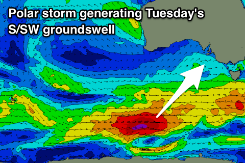 Monday is hit and miss with a low point in swell during the morning and E/SE winds, likely tending E/NE for a period down South, but later in the day our new long-period S/SW groundswell should start to show, with a peak due Tuesday.
The swell will be generated by a strong polar low firing up on the tail of the mid-latitude low, with a good fetch of severe-gale (to at its peak storm-force W/SW winds) through our south-west and then southern swell window.
The low will continue east and under Tassie, with the groundswell peaking Tuesday morning to a strong 4-5ft off Middleton, while the Mid Coast looks tiny and to 1ft+.
Unfortunately a weak front and new ridge of high pressure will move in bringing freshening S/SW tending SW winds, persisting from the SW Wednesday morning as the swell eases. There's an outside chance of an early W/NW breeze Wednesday morning, but we'll review this Monday. Longer term there's nothing too significant on the cards, so make the most of the weekend's waves. Have a great weekend!
Comments
Not trying to piss in anyone's milk here, but every single wind model and forecast I have seen shows SW winds between 13 and 18 knots for both the South and Mid coasts on Saturday morning. Even the Swellnet graph shows SW at 13 knots. How are you calculating a W/NW wind down south for Saturday AM? Only asking to further my knowledge!
Just under this scenario local topography steers the wind more W/NW for a period.
The latest update has actually gone more W/SW so could be semi-dicey but I have faith.
Thanks!
Personally the next day looks the pick IMO ;)
Looks like the local effects didn't kick in this morning, bummer but this is the way the model updates tended into the afternoon aghh!
So Sunday with a southerly rather than chance the W/NW Saturday morning?
Just that I need to set the alarm for 4.30am if its a chance Saturday.
Yeah, just because tomorrow looks dicey and the swell won't be in yet and west. More size, and with a weak onshore wind Sunday. If you don't mind a slight bump with more size Sunday looks the go.
Personal preferences and probably given enough away.