Good W/SW swells next week, though with average winds
South Australian Forecast by Craig Brokensha (issued Friday 25th May)
Best Days: South Coast swell magnets early tomorrow, keen surfers Mid Coast Monday, South Coast Tuesday morning
Recap
Variable winds and fun surf off Middleton hanging in at 3ft, while the Mid Coast saw some sneaky tiny 1ft waves through the day.
Similar sized surf has been seen today on the Mid, while the South Coast offered more size with a new S/SW groundswell to 3-4ft off Middleton, a touch under the expected 4-5ft sets. Conditions are favourable though with a variable offshore tending NE breeze.
Today’s Forecaster Notes are brought to you by Rip Curl
This weekend and next week (May 26 – Jan 1)
This morning's S/SW groundswell will ease off steadily through the day, leaving small leftovers tomorrow across the South Coast, tiny on the Mid with a gusty N/NE breeze.
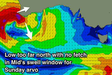
 Moving into Sunday and our large and acute W'ly groundswell has totally changed unfortunately with the severe low off WA forming too far north and out of our western swell window.
Instead of seeing severe-gale to storm-force W'ly winds through our swell window this evening, we're not expected to see anything, with the winds aimed into WA.
As the low starts weakening and pushing east through the Bight we'll see a much weaker fetch of strong to gale-force W/SW winds aimed through the Mid Coast's swell window, projecting east and weakening through tomorrow.
This will result in no W'ly swell at all for Sunday, with a later arrival time of Monday and to a good 2-3ft on the Mid Coast. The South Coast will remain small to tiny with maybe stray 1-2ft sets at Middleton, mostly likely into the afternoon with the arrival of a long-range SW groundswell.
 Therefore Sunday looks a lay day with gusty N/NW tending NW winds, not too flash Monday with a continuation of fresh N/NW winds.
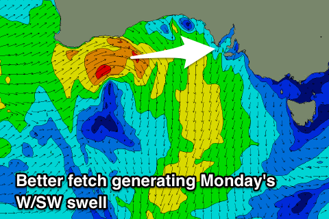
The long-period SW groundswell signal expected Monday afternoon across the South Coast should peak Tuesday morning, generated by an intense polar low the last couple of days in the south-east Indian Ocean.
Middleton should see 2-3ft sets off this, but this will be overridden by a closer-range W/SW-SW swell, generated by an intense low forming south of the Bight Sunday.
A fetch of strengthening W/SW winds will be projected through both our swell windows, producing a good pulse of swell for Tuesday afternoon.
The Mid Coast is likely to kick to 2-3ft on Tuesday, with Middleton increasing to 3ft+ through the afternoon.
Winds look average for the Mid Coast as a weak mid-latitude front pushes in from the west bringing fresh W/NW tending SW winds, which will also bring an increase in localised windswell.
The swell looks to ease back through Wednesday with lingering onshore winds improving into the afternoon. The models still diverge around this, but we're likely to see a strong high move in, bringing N/NE winds late week and deflecting swell generating systems away from us, relying on longer-range energy which there looks to be fun amounts of, but more on this Monday.
Have a great weekend!

