Easing surf tomorrow, building stormy swell Sunday and Monday, great Tuesday
South Australian Forecast by Craig Brokensha (issued Friday 23rd March)
Best Days: Saturday morning South Coast, Mid Coast later Monday, Tuesday South Coast, Friday morning South Coast
Recap
Tiny surf across the Mid Coast the last two days, much better down South with solid sets still coming in at 3-4ft across Middleton with morning offshores.
This morning the surf was back to a small 2ft off Middleton but a great size for Waits and Parsons with a straight offshore wind. A new inconsistent S/SW groundswell should provide bigger sets into this afternoon as winds remain favourable until mid-late afternoon.
Today’s Forecaster Notes are brought to you by Rip Curl
This weekend and next week (Mar 24 - 30)
This afternoon's increase in S/SW groundswell is expected to ease back through tomorrow, dropping from 2ft to occasionally 3ft across Middleton early, smaller into the afternoon.
Winds are now looking funky, with dawn possibly being a little average with lingering SE winds, but we should see a light offshore develop through the morning and W'ly into the afternoon. The Mid Coast will be tiny to flat.
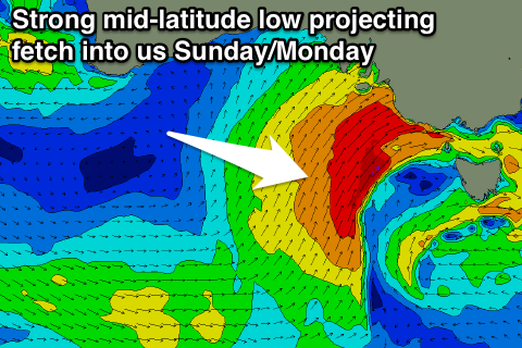
 Moving into Sunday a strengthen mid-latitude low will project a fetch of strengthening strong to gale-force W/SW veering SW winds into us, kicking up a building stormy swell on the Mid Coast to 3-4ft into the late afternoon with strengthening W/NW tending W/SW winds.
The South Coast will be small to tiny during the morning, building later in the day as the low pushes ease.
Come Monday morning large messy surf to a stormy 6ft+ is expected, easing steadily through the day as the mid-latitude low continues east and a small high moves in from the west.
Conditions will still be poor with strong but easing SW winds. The Mid Coast should ease back from 3ft+ with improving conditions as the onshore winds ease (best later in the day).
Tuesday looks excellent as the swell continues to ease, with a persistent offshore N/NE tending N/NW wind and easing swell from 3ft to occasionally 4ft off Middleton, back to 2ft max Wednesday morning.
The Mid Coast will drop right away as well with the swell going more south, resulting in fading 1ft sets.
On Wednesday as the swell continues to ease, W/NW-SW winds will create less than ideal conditions.
Moving into Thursday and Friday and we're due to see good pulses of W/SW swell as a flurry of relatively weak but sustained mid-latitude fronts push in from under WA.
An initial weak front Tuesday and Wednesday looks to produced 1of windswell for the Mid Coast Wednesday, slightly bigger Thursday morning and to 1-1.5ft.
A secondary broader front should produce a better increase in swell later Thursday and Friday to 2ft or so, while the South Coast is only due to kick later Thursday to 2ft+ off Middleton, more around 3ft+ Friday. Winds look to be generally from the west, but more on this Monday. Have a great weekend!


Comments
Standup on a really nice bowly section at Knights earlier today (right click, open in new tab, and you'll see it's a decent size too!).

In town for 24 hours and managed a fun arvo stormy an an old favourite. Checked a few Mid Coast locales mid-afternoon, was a pretty solid 4ft though very sloppy. Plenty of small waves up on the metro beaches too.