Plenty of swell this week, cleanest Friday
South Australian Forecast by Craig Brokensha (issued Monday 12th March)
Best Days: South Coast Friday, Saturday morning
Recap
Great conditions with a small to tiny leftover swell on Saturday down South, tiny and bumpy yesterday.
The Mid Coast was flat with clean conditions Saturday bumpy yesterday. Today a tiny windswell has come up to 0.5-1ft on the Mid Coast while the South Coast is a sloppy 2-3ft.
Today’s Forecaster Notes are brought to you by Rip Curl
This week and weekend (Mar 13 - 18)
This morning we saw a poor quality S'ly windswell across the South Coast, but we should see some better S/SW groundswell filling in later and peaking tomorrow morning.
During the weekend we saw a strong polar front projecting a fetch of W/SW gales through our southern swell window, with a secondary fetch firing up on its tail last night and through this morning.
This has generated a moderate sized S/SW groundswell for later today and tomorrow morning, with reinforcing energy for Wednesday.
Middleton should come in around 3-5ft tomorrow, back to a slightly smaller 4ft or so Wednesday. The Mid Coast should be biggest tomorrow with 1-1.5ft sets on the favourable parts of the tide (not much movement), back to 1ft+ Wednesday.
The swell should still be up Thursday morning as a third pulse of S/SW groundswell fills in from a fetch of W/NW gales swinging in from the south-east Indian Ocean today.
 Middleton should still see 3ft to occasionally 4ft sets Thursday morning before easing through the day. The Mid Coast is likely to drop to 1ft, with 0.5-1ft sets Friday.
Winds will unfortunately be onshore from the SE tending S/SE across the South Coast tomorrow and Wednesday (weaker on the later). Thursday looks similar, though there's an outside chance for more variable breezes through the morning which I'll review Wednesday.
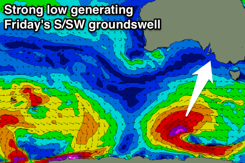
Friday is looking much cleaner with a NE-N/NE wind and a strong new S/SW groundswell filling in through the day.
This groundswell will be generated by a polar low forming south-west of Tassie tomorrow evening, projecting a fetch of severe-gale to storm-force SW winds up towards that state, through our southern swell window.
We'll see a strong and sizey S/SW groundswell filling in during Friday and peaking into the afternoon to 4-6ft across Middleton. Those morning offshores will likely last until early-mid afternoon before sea breezes kick in.
The Mid Coast won't see any size off this low due to its placement south of Kangaroo Island.
Into the weekend the S/SW swell will ease back across the South Coast with morning offshores, smaller Sunday.
Longer term another strong node of the Long Wave Trough is forecast to move in from the west next week, bringing a large dose of windy surf, but more on this Wednesday.

