Clean small surf tomorrow, fun Mid waves Thursday
South Australian Forecast by Craig Brokensha (issued Monday 26th February)
Best Days: South Coast magnets tomorrow, Mid Coast Thursday and novelty waves Friday
Recap
Poor onshore winds across both coasts on Saturday with a building swell down South, tiny on the Mid. Sunday remained average with fresh onshore winds down South and cleaner but tiny 1ft surf on the Mid.
This morning was much better down South with an E/NE breeze and peaky 3ft of swell, while the Mid Coast continued to tease at 0.5-1ft.
Today’s Forecaster Notes are brought to you by Rip Curl
This week and weekend (Feb 27 – Mar 4)
Conditions will clean right up through tomorrow with a N/NE offshore down South, tending more N/NW and likely variable mid-late afternoon.
Today's swell will drop away though, with an infrequent background SW groundswell providing 1-2ft sets at Middleton, with a touch more size at Waits and Parsons.
The Mid Coast will also be clean but tiny to flat.
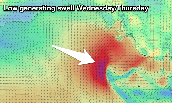
Into Wednesday a small mid-latitude low pushing in from the west will bring gusty W/NW tending W/SW and then SW winds along with a building W/SW windswell.
 The Mid Coast should build to a semi-stormy 2-3ft into the afternoon, while the South Coast is only due to build later in the day, reaching 3ft+ or so off Middleton though with those poor SW winds.
Into Thursday the swell should be a touch stronger and much cleaner on the Mid Coast with 2ft+ sets and S/SE winds, poor down South with 3ft to occasionally 4ft sets off Middleton.
A new SW groundswell will also be in the mix, produced by a strong polar low that's currently just east of the Heard Island region.
A fetch of gale-force W'ly winds were generated over the weekend, with a weakening fetch of strong to gale-force winds being projected along the polar shelf over the coming two days, broadening while continuing to weaken and passing under the Bight tomorrow and Wednesday.
The swell from the fetch moving under the country should fill in Thursday, coming in around 3ft across Middleton, mixed in with the swell from the mid-latitude low, holding a similar size Friday, with long-period energy from the weekend offering less frequent 3ft sets Saturday morning.
The Mid Coast isn't likely too see much size, with 1-1.5ft sets Friday back to 1ft Saturday.
A high moving in from the west Friday should swing winds more E/NE down South, average Saturday as a weak trough deepens bringing freshening S/SE winds.
These winds will generate some weak S/SE windswell for Sunday and Monday, possibly persisting all next week while building in size, but more on this Wednesday.

