Poor, easing surf; brief window down south Thursday afternoon
South Australian Surf Forecast by Ben Matson (issued Monday 19th February)
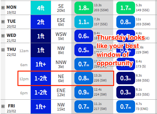
Best Days: Thurs: small window of waves through lunch/early arvo with a small new swell and an offshore breeze.
Recap: Saturday delivered great waves down south through the morning, with a strong swell and an offshore breeze. Fresh onshores kicked in around lunchtime and they’ve maintained poor quality surf ever since. There hasn’t been enough size on the Mid to bother with.
Today’s Forecaster Notes are brought to you by Rip Curl
This week (Feb 20 - 23)
Today’s notes will be brief as Craig’s on leave.
Gusty S/SE winds off the state's south-east coast will maintain short range windswells at Victor through Tuesday though there won’t be much quality around. Wave heights should maintain 3ft or so, and there’ll be a uniform size distribution owing to the swell direction. A small underlying groundswell today will ease back in size, and probably won't be noticeable.
Quality will be average at best anyway on Tuesday; we will see the airstream ease up locally for a few hours in the morning, and this may see some of the surface chop die down but it’ll be lumpy at best. Even if this occurs, onshores will redevelop into the afternoon.
Tuesday's southerly windswell will ease through Wednesday, and light variable winds will maintain lumpy conditions. We may see periods of northerly winds but without any strength it won’t be enough to iron out the bumps.
Tiny to flat conditions will prevail across the Mid Coast both days.
Winds will slowly freshen from the north on Thursday. Initially, wave heights will be very small but a small, long range groundswell is expected into the afternoon and through Friday, generated by a reasonable low well SW of WA over the weekend. This won’t be enough to generate much more than a tiny line of swell on the Mid Coast (0.5-1ft absolute best, very slow and weak) but we should see some small clean lines at Victor to 2ft at Middleton and 3ft at Waits, Parsons and Goolwa. Expect very long breaks between the sets.
Winds are tricky for Friday though. The remnants from TC Kelvin are expected to make their way across continental WA over the coming days, entering the Bight around Thursday and forming a cut off low. However the models aren’t in agreement as to exactly where the low will form - some solutions have it slightly north (resulting in E’ly winds and poor surf at Victor, and little swell potential for the Mid), other models have it a little further south, resulting in more N/NE winds for Victor and a decent SW fetch in the Bight that’d generate a weekend swell for the Mid Coast.
Let’s see how Wednesday’s model runs are looking. For now, Thursday afternoon is your best bet at Victor.
This weekend (Feb 24 - 25)
The weekend forecast is complex, all hinging around this cut-off low in the Bight, being the remnants of TC Kelvin.
An onshore change is expected at some point as the low transitions across the region, though I’m not sure yet whether it’ll be a W/SW change (and a swell for the Mid) or a S’ly change (and no swell for the Mid). Gut feel is that it'll be pretty ordinary on both coasts, both days.
We really need a few more days to firm things up, so let’s take a closer look on Wednesday.
Next week (Feb 26 onwards)
Nothing of any major interest showing up at this stage, just a seasonal progression of average fronts through the Southern Ocean. There is one suggestion for a strong front to enter the western Bight over the weekend which could generate a solid swell for the Mid Coast early/mid next week, but that’s a long time away for now.


