Fun days ahead for both coasts
South Australian Forecast by Craig Brokensha (issued Wednesday 20th December)
Best Days: Both coasts Thursday morning, South Coast and Saturday mornings (keen surfers on the Mid for tiny waves)
Recap
Tiny surf across both coasts yesterday, though some new W/SW swell built through the afternoon across the Mid Coast but with onshore winds.
This morning we've got a mix of mid-period W/SW swell and building SW groundswell, coming in at a choppy 2ft on the Mid Coast, while the South Coast was tiny and clean early, but an onshore change has since moved through with building surf.
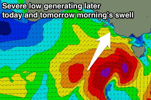
This building swell is linked to a severe low that formed south-west of us yesterday evening. A great fetch of severe-gale W/SW winds have generated a strong SW groundswell for later today that should reach 3-4ft off Middleton, while the Mid Coast is likely to see 2-3ft sets with the incoming tide. Cape du Couedic is showing size, but until that period climbs, it's just weak windswell/mid-period swell..

Today’s Forecaster Notes are brought to you by Rip Curl
This week and weekend (Dec 21 - 24)
 A severe low is currently sitting south-west of Tassie, with a significant fetch of severe-gale W/SW-SW winds being generated in our south-western and southern swell windows. Satellite observations have picked up a couple of storm-force barbs on the edge of our swell window, and the swell off this low is expected to peak tomorrow morning across the South Coast.
The Middleton should see surf in the 4ft range early, easing through the day, while the Mid Coast is due to ease back to 2ft.
Winds are looking favourable for both coasts with a variable morning breeze, likely tending S/SE across the Mid Coast and maybe W/NW down South. In any case there should be fun waves on offer through the morning before sea breezes kick in.
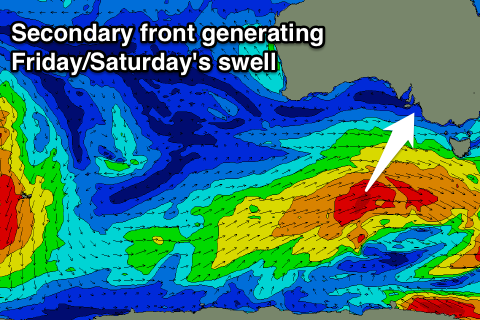
A low point in swell is expected Friday morning, but a secondary vigorous polar front will generate a strong reinforcing S/SW groundswell for the afternoon.
 This secondary front is currently forming south of WA and will project a great fetch of gale to severe-gale W/SW winds towards Tasmania, through our southern swell window.
Friday morning looks to be around 3ft off Middleton, but the new swell should kick back to a stronger 4ft on the sets into the mid-late afternoon, while the Mid looks to hold around 1-1.5ft.
A peak in swell is due overnight, with a slow drop from 3-4ft Saturday morning down South and 1-1.5ft at magnets on the Mid Coast.
Winds on Friday look great for both coasts during the morning with a light NE'ly on the Mid and N/NE'ly down South before sea breezes kick in. Saturday will be great as well with moderate N/NE'ly tending N/NW wind before sea breezes kick in.
Unfortunately moving into Sunday we'll see a strong ridge of high pressure moving in from the west, bringing with it a strong S/SE change creating poor conditions down South while the Mid Coast will be cleaner but tiny.
This high will spoil the surf through Monday when a mid-period reinforcing S/SW swell is due, while slightly better E'ly winds are expected Tuesday as the swell eases. Longer term the outlook isn't too amazing, so make the most of the coming days!

