Easing surf ahead of some good new swell from Friday
South Australian Forecast by Craig Brokensha (issued Monday 11th December)
Best Days: Spots that like a NE wind Tuesday morning, swell magnets Wednesday morning, South Coast Saturday and Sunday mornings
Recap
Tiny little fun waves on the Mid Coast Saturday to 1-1.5ft, dropping back to 0.5-1ft yesterday, even smaller this morning.
The South Coast provided fun waves Saturday with a variable wind and small swell, bigger and better Sunday with a new S/SW groundswell and light offshore wind.
This morning the swell was still hanging in at 2-3ft off Middleton with fun conditions before the sea breeze kicked in again.
Today’s Forecaster Notes are brought to you by Rip Curl
This week and weekend (Dec 12 - 17)
The weekend's swell was generated by a strong polar frontal system strengthening south of us, with a secondary weaker front, generating a reinforcing swell for today.
This swell is expected to ease back through tomorrow from 2ft to occasionally 3ft off Middleton, smaller Wednesday and tiny to flat on the Mid Coast.
Winds will be out of the NE tomorrow morning, favouring Goolwa, Waits and Parsons before sea breezes kick in, with better N'ly winds Wednesday but only small fading sets at South Coast magnets.
Thursday is a lay day with tiny surf and onshore winds in the wake of a change.
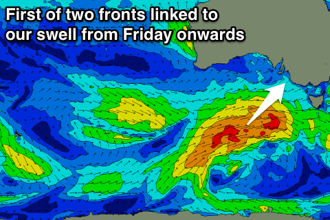
 Our new swells due later in the week and weekend are still on track, with a good frontal progression that's currently south-west of WA due to strengthen while slowly moving east through this week.
Distant W/SW energy is due from the current storm, but a more consistent and bigger SW swell should be produced as a good fetch of strong to near gale-force W/SW winds develop south of the Bight mid-late week.
A secondary fetch of strong W/SW winds projecting closer to us Friday and Saturday will then produce a reinforcing SW swell. The models diverge on the secondary front generating this swell, with it possibly coming in larger, but more on this Wednesday.
The first pulse of W/SW and SW energy will build through Friday and peak into the afternoon with 3-4ft sets expected to develop across Middleton, and 1-1.5ft on the Mid Coast.
A temporary drop should be seen into Saturday morning ahead of the reinforcing swell later in the day.
Middleton should hang around 3ft or so, with 1-1.5ft sets on the Mid Coast (mixed in with possibly the odd bigger one on the incoming tide, similar into Sunday morning.
Winds look best for the South Coast with morning W/NW breezes likely Friday through Sunday ahead of afternoon sea breezes. Check back Wednesday for a more accurate outlook though.


Comments
Old mate scoring a little inside section at the Bay this morning.
