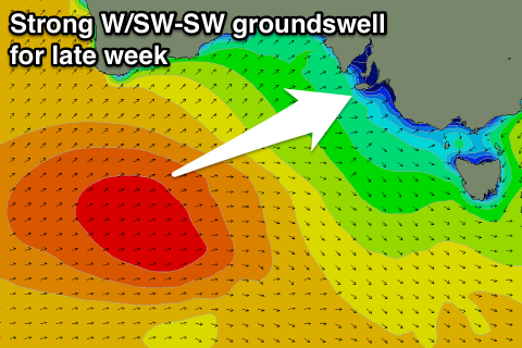
Fading swell with offshore winds, good W/SW swell late week, cleanest on the Mid
South Australian Forecast by Craig Brokensha (issued Monday 16th October)
Best Days: South Coast swell magnets tomorrow morning, Mid Coast Friday and Saturday
Recap
Plenty of swell Saturday with a new S/SW groundswell coming in around 3-4ft though with less than ideal conditions. Keen surfers found fun peaky waves in spots that like east in the wind.
Sunday was similar and not too appealing with variable winds and bumpy/lumpy surf as the swell dropped back to 2-3ft.
The Mid Coast offered a bit more size then expected, hanging in at 1-1.5ft Saturday and a similar but less consistent size Sunday.
Today a reinforcing SW swell has kept wave heights around 2-3ft off Middleton while the Mid Coast has 0.5-1ft sets with a light morning NE breeze. Conditions improved across spots that love a NE wind during the morning and winds are still holding.
This week and weekend (Oct 17 - 22)
This morning's reinforcing SW groundswell was generated over the weekend by a strong but unfavourably aligned fetch of W/NW gales through our swell window over the weekend, but a strong high has since moved in behind this, and we'll see the swell drop and bottom out through the middle of the week.
If you want to surf, go South tomorrow morning for easing 2ft sets off Middleton (larger Waits and Parsons) under a fresh N/NE offshore wind, tending variable through the afternoon.
 The Mid Coast will be effectively flat, while come Wednesday so will the South Coast under morning N'ly offshores and weak afternoon sea breezes.
From Thursday we should see the surf starting to build, initially out of the W, ahead of a better increase in W/SW tending SW groundswell Friday.
The first pulse of small W'ly swell for Thursday will be generated by a short-lived fetch of strong W/SW winds under the south of WA early tomorrow morning as a mid-latitude low quickly dips south.
The Mid Coast should build to 1ft though with onshore winds SW tending S winds, while the South Coast will remain tiny, with a very weak increase in windswell later.
Of greater importance is a mid-latitude front firing up south-west of WA, on the back of a previous front and generating a great fetch of W/SW gales initially through our western swell window, slipping more into out south-western swell window while strengthening a touch Thursday.
We should see a moderate to large W/SW tending SW groundswell from this system, filling in Friday and building from 1-2ft during the morning on the Mid to 2-3ft during the late afternoon with the incoming tide. The South Cost looks small early and around 1-2ft off Middleton, building late in the day to 4ft.
Winds will be best for the Mid Friday as a ridge moves in behind Thursday's change bringing freshening S/SE winds, similar into Saturday as the swells ease from 2ft on the Mid and 3-4ft down South off Middleton.
The swell will continue to ease into Sunday with plenty of reinforcing SW swell for the South Coast, though with onshore winds for the most part. The Mid looks cleaner but tiny. More on this Wednesday.


Comments
Haven't see it this small at Victor for a while!
Off topic but is the Fish cage in place at Victor ?
Not sure. Press release in early July said it would be ready to "welcome the first visitors next month".