Fun W/SW swell tomorrow, with SW energy late week
South Australian Forecast by Craig Brokensha (issued Monday 9th October)
Best Days: Both coasts tomorrow, South Coast Wednesday morning, protected spots South Coast Thursday, both coasts Friday (Mid Coast mid-late arvo), Saturday morning both coasts, Sunday morning South Coast
Recap
Fun improving surf down South on Saturday with a mix of swells and swing in winds, more offshore into the afternoon. Sunday was a bit smaller but nice and clean again through the morning before a change pushed through into the afternoon.
The Mid Coast was tiny all weekend, but today the first of two W/SW swells has filled in with 1-1.5ft sets though with onshore winds. The South Coast was still small and clean with variable winds which have since gone onshore.
This weekend and next week (Oct 7 - 13)
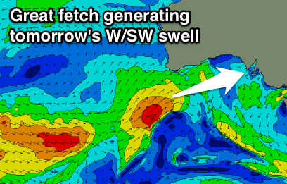
On the incoming tide this afternoon we should see a bit more size showing across the Mid Coast, pulsing to 2ft as onshore winds back off a little. The South Coast should also increase in size, but our best increase in W/SW swell is expected tomorrow, generated by the second of two polar fronts firing up towards and into WA and then through the Bight over the weekend.
We should see good 2-3ft sets on the favourable parts of the tide tomorrow across the Mid Coast with 3ft to occasionally 4ft waves off Middleton during the morning, easing into the afternoon and further Wednesday.
Winds tomorrow morning are looking great for both coasts and offshore from the NE, tending variable on the Mid into the afternoon and variable from the N'th down South.
Into Wednesday a freshening N/NW breeze will hold until a W/SW change moves through early-mid afternoon. Middleton should be easing from 2-3ft with 1-2ft sets on the Mid.
 Wednesday afternoon's change will likely kick up a late increase in windswell on the Mid Coast, though not above the size of the easing W/SW groundswell.
Into Thursday though we'll see some better W/SW swell filling in from the front bringing the change, with it currently sitting west-southwest of WA. The front will project a fetch of strong but weakening W/SW winds towards us over the coming days, with the swell for Thursday coming in at 2ft on the Mid Coast and 3ft+ across Middleton.
A secondary front pushing through and under us Thursday should produce two bursts of stronger W/SW gales through our south-western swell window, producing some fun new SW groundswell for Friday afternoon and Saturday morning.
Middleton should increase towards 3-4ft Friday afternoon, easing from a similar size Saturday while the Mid Coast looks to persist at 2ft on the sets.
W/NW winds are expected most of Thursday, possibly tending W/SW for a period into the afternoon, with early W/NW breezes Friday, tending S/SE down South, while the Mid looks to offer variable breezes.
Into the weekend as the SW swell eases light variable tending locally offshore winds are due across both days.
Longer term there's nothing significant on the cards as a large blocking high moves in from the west, but more on this Wednesday.


Comments
Good to see the new swell pushing into the Mid Coast this arvo..