Lots of swell on the way, cleanest early next week
South Australian Forecast by Craig Brokensha (issued Friday 29th September)
Best Days: Protected spots early each morning down South over the weekend, much better Monday. Tuesday and Wednesday mornings. Mid Coast on the favourable parts of the tide Monday and Tuesday
Recap
A kick in W/SW swell across the Mid Coast yesterday but with onshore winds, easing into the afternoon with the swell. The South Coast saw some fun new S/SW swell building through the day but early W'ly winds gave into an onshore change.
This morning a fun new S/SW swell has come in across the South Coast with clean 3-4ft waves off Middleton while the Mid Coast was tiny and bumpy. The swell should hold all day down South as winds tend more W/NW and freshen.
This weekend and next week (Sep 30 – Oct 6)
From this weekend we've got a great run of swell expected across the region with back to back polar fronts firing up through the Southern Ocean.
Currently the strong polar low linked to the weekend's swell has formed south of WA, with a broad fetch of gale to severe-gale W/SW winds being generated through our south-western and southern swell windows.
This low will continue east through today while weakening slightly. In saying this we'll see a great fetch of W/SW-SW gales pushed right up under the South Coast this evening and early tomorrow.
What we can expect is a moderate to large sized SW tending S/SW swell, with mid-period energy through tomorrow morning, followed by stronger groundswell energy into the mid-late afternoon.
 Middleton is expected to be around the 5ft range tomorrow morning, building to a touch further through the afternoon, then easing from 4-5ft+ Sunday morning.
The swell direction isn't ideal for the Mid Coast but 2ft surf is expected on the favourable parts of the tide tomorrow, easing back from 1-2ft Sunday.
Now, with the front moving through overnight, winds will be generally out of the W/SW-SW tomorrow, with the Victor region more than likely to see early W'ly winds, favouring protected spots.
Sunday looks similar with an early W/NW breeze around Victor, swinging SW into the afternoon.
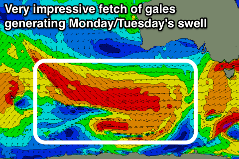
Moving into next week and forming right behind the strong polar low linked to the weekend's swell is a more impressive fetch of elongated and broad W/NW tending W'ly gales.
This should generate a moderate to large sized reinforcing SW groundswell for Monday, building into the afternoon, holding Tuesday morning and then slowly easing later in the day, further Wednesday.
We should see Middleton building back towards 5ft Monday afternoon, holding a similar size Tuesday morning, easing late and dropping from 3ft to occasionally 4ft Wednesday morning.
The Mid Coast should see small surf to 1-1.5ft, likely reaching 2ft at times with the incoming tide on Monday and Tuesday morning.
Winds are looking excellent early next week with light local offshores Monday morning ahead of afternoon sea breezes, similar Tuesday while winds will freshen from the NE Wednesday as a deep mid-latitude low deepens in the Bight. The models are still divergent regarding this though, so check back here Monday for an update on this.
Have a great weekend and go the Crows!


Comments
Strong lines in the Bay this afternoon. That inside line is easily head high!