Fun waves Friday with larger surf over the weekend, great early next week
South Australian Forecast by Craig Brokensha (issued Wednesday 27th September)
Best Days: South Coast Friday, early Saturday and Sunday mornings, early-mid next week, Mid Coast Monday and Tuesday morning
Recap
Excellent conditions across the Mid Coast yesterday but with a tiny leftover swell in the 1ft+ range. The South Coast saw fun sized surf and clean conditions at locations that like a north-east wind.
Today the Mid Coast was flat while the South Coast was nice and clean with fun waves at swell magnets.
This week and weekend (Sep 28 – Oct 1)
Tomorrow isn't looking like a good surf day with a weak mid-latitude low that's currently moving in from the west due to bring a SW change just before dawn tomorrow.
This will create poor conditions with some new S/SW groundswell to 2-3ft off Middleton down South, while the Mid Coast is looking to offer weak 1-1.5ft sets, with the fetch of W/SW winds through our swell window being poor.
Friday is looking much better with a new mid-period S/SW swell, generated by a broad but not overly strong polar front projecting up through our swell window today and tomorrow.
The swell is expected to peak through the afternoon with 3ft to occasionally 4ft sets off Middleton (only a touch smaller through the morning) along with NW tending W/NW winds. The Mid won't see any size with tiny 1ft sets, with a late increase in messy windswell.
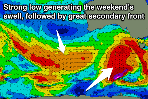
Friday's freshening W/NW'ly will be linked to a more vigorous polar frontal progression approaching from the south-west, linked to a strong node of the Long Wave Trough developing over us.
The structure of this system has changed a little with core wind speeds not expected to reach the storm-force range any more.
This will result in a bit less size than forecast on Monday, but coming back to the storm and a great broad fetch of gale to severe-gale W/SW tending SW winds being projected nicely through our swell window, moving under us Friday afternoon.
 A large SW tending S/SW groundswell is expected off this low, building through Saturday, peaking overnight and easing Sunday.
Middleton should see 3-5ft waves early, building more towards 6ft into the afternoon, and then easing back from 4-5ft+ Sunday morning.
The Mid Coast should see 2ft surf on Saturday, easing back a touch to 1-2ft Sunday.
Winds will be best for protected locations on the South Coast with a general moderate to fresh W/SW breeze (W/NW early around Victor Saturday and Sunday morning), with winds being a little lighter on Sunday and tending SW into the afternoon.
Next weekend onwards (Oct 2 onwards)
We'll see great waves across the South Coast into early next week as a very drawn out secondary frontal system develops on the tail of the initial strong low.
A great fetch of W/NW gales will persist through our western swell window from Friday afternoon through Sunday while slowly moving east, angling away from our swell window.
What we should see is moderate amounts of SW groundswell spreading out radially from this fetch, building later Monday and peaking Tuesday morning.
Middleton should hold around 4ft through Monday on the sets, similar Tuesday morning before easing into the afternoon, further Wednesday.
The Mid Coast looks to also persist around 1-2ft on the favourable parts of the tide Monday and Tuesday morning, becoming tiny into Wednesday.
Conditions look excellent with light N/NE winds on Monday morning ahead of afternoon sea breezes, light N'th Tuesday morning and fresher from the NE on Wednesday as a mid-latitude low approaches from the west. More on this Friday though.

