Large messy swells for the Mid Coast, cleaning up Saturday
South Australian Forecast by Craig Brokensha (issued Wednesday 16th August)
Best Days: Protected spots down South Thursday and early Friday, Mid Coast Saturday, South Coast early Sunday and early next week
Recap
After a good kick in swell Monday afternoon and evening, Tuesday hung in around 2ft on the Mid Coast but winds weren't as favourable with a freshening N'ly, swinging more onshore through the day.
The South Coast saw small levels of W/SW swell, best through the morning.
Into today a larger increase in W/SW swell was seen on the Mid to a choppy 3-4ft across the Mid Coast, while the South Coast was windy and around 2-3ft off Middleton, with the westerly swell failing to get in with any real size as of yet.
A vigorous front passing under is today, linked to today's winds has generated a stronger pulse of swell for this afternoon down South, with sets due to reach 3-4ft off Middleton as winds hold from the W/NW.
This week and weekend (Aug 17- 20)
The frontal system linked to this afternoon's increase in W/SW swell is passing to the east, and with this the swell will drop a touch down South, but the Mid Coast will build to a stormy 4ft as a new mid-latitude front pushes into the region. The morning may be a little undersized but strengthening W/NW tending W winds will kick up large amounts of stormy swell through the afternoon.
Middleton should ease back from the 3ft+ range and those strong W/NW tending W winds will only favour protected spots.
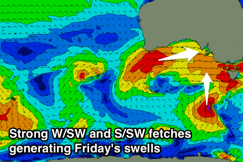
Into Friday groundswell from the early stages of the mid-latitude front today should fill in. A fetch of weakening gale to severe-gale W/SW winds are being projected through our western swell window, with a large W/SW groundswell due to fill in Friday.
 We should see 3-4ft sets on the Mid Coast, while the South Coast is due to also come in at a solid 4ft off Middleton.
There'll also be a new S'ly swell into the afternoon, generated by a strong polar fetch of gale to severe-gale S'ly winds developing south of us today. This fetch will move slowly east this evening and tomorrow, but the strength and alignment of the fetch should see some good swell produced across our region.
It'll be hard to see under the W/SW Friday, but come Saturday morning Middleton should still be offering 3-4ft sets early ahead of a steady drop in size through the day, down from 2ft Sunday.
The Mid Coast will ease off steadily Saturday from 2-3ft, down from 1-1.5ft if that Sunday.
Winds are due to be onshore from the W/SW on Friday, though the Victor region will likely see an early W/NW'ly, and the Mid Coast will be best Saturday with S/SE tending variable breezes (S/SW tending S/SE down South). Strengthening N/NE winds Sunday will favour exposed breaks down South during morning before blowing out the surf into the afternoon.
This strengthening northerly will be linked to an intense mid-latitude approaching from the west and with this we'll see another messy W/SW swell whipping up for the Mid Coast Monday, while the swell will be generated too far north for the South Coast.
Instead some fun new SW groundswell is due from a strong polar frontal system, followed by a better pulse Tuesday and Wednesday, but more on this Friday.

