Workable weekend, small and offshore most of next week
South Australian Forecast by Craig Brokensha (issued Friday 12th May)
Best Days: South Coast spots that like NE winds the next two days, South Coast Tuesday and Wednesday
Recap
A great example of a very long-range and long-period groundswell arriving 24 hours behind when the swell was actually picked up on the Cape du Couedic wave buoy. The reason for this is discussed in more detail here if you're interested: Why The Swell Train Is Often Late. But what we saw yesterday was a slow start to the day on both coasts before the groundswell filled in mid-late morning, pulsing strongly with the incoming tide on the Mid Coast.

Consistent 2ft waves were seen across the gulf, with 3ft sets at magnets and light variable winds created great conditions all day. The South Coast was also excellent as the swell built through the day along with those light variable winds.
This morning the swell was back to an inconsistent 1-1.5ft on the Mid Coast and 2-3ft off Middleton with local offshore winds.
This weekend and week (May 13 – 19)
The weekend will consistent of S/SW swell and E/NE-NE winds.
A new S/SW swell is due this afternoon across the South Coast, produce by a flurry of broad but not overly strong polar fronts under the country the last couple of days.
We should see this afternoon's increase easing through tomorrow, back from 3ft on the sets across Middleton, smaller and more so 2ft Sunday. The Mid Coast will be tiny with no significant swell moving into the gulf with the southerly direction.
Conditions will be OK but not great and best at Goolwa and Parsons with an E/NE-NE offshore both Saturday and Sunday mornings.
Monday will see similar NE winds, but the surf will be smaller and fading from 1-2ft at Middleton (2-3ft at Waits and Parsons). A tiny W/SW swell may be seen on the Mid Coast Monday, coming in at a very inconsistent 1ft on the sets, generated the last two days in the south-east Indian Ocean. This will provide beginners some waves on the beaches.
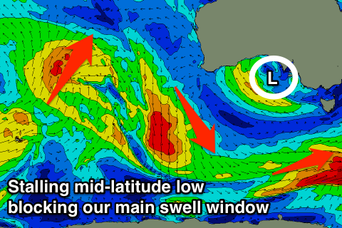
As talked about last update, a slow moving mid-latitude low drifting in from the west next week will direct offshore winds from the north-east quadrant for most of the week.
 The low will sit too high to generate any W'ly swell at all for the Mid Coast, while the South Coast will have to rely on a small but fun S/SW groundswell Tuesday and Wednesday (small to tiny from there on).
This groundswell will be generated by a strong polar front, generating pre-frontal W/NW gales through our southern swell window.
It won't be the greatest swell, but should build through Tuesday to 2ft to occasionally 3ft across Middleton into the afternoon, easing back from 2ft Wednesday morning. Fresh and gusty N/NE tending N'ly winds will create good conditions all day Tuesday, with fresh N/NE winds all day Wednesday.
For the rest of the week and into the following weekend there's nothing major due, a result of the stalling mid-latitude low across our swell window all next week. Therefore make the most of the small S/SW groundswell pulse early-mid next week. Have a great weekend!

